Title:
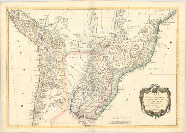
“Carte qui Represente la Partie Meridionale du Bresil et du Perou, le Chili Septentrional, et le Paraguay; ce qui Fait la Partie de Milieu de l'Amerique Meridionale”
Map Maker:
Anville/Santini
This handsome map of the central section of South ... (full text available to subscribers)
| Item Detail |
| |
| |
MapMaker: |
Anville/Santini
|
|
| |
| |
Subject: |
Central South America |
|
| |
Period/Size: |
1779 / 18.8" x 26.7" (47.8 x 67.9 cm)
|
|
| |
Color: |
Colored
|
|
| |
Condition: |
(B+) A crisp impression on a bright sheet with an "Imperial VO" watermark. There is light offsetting along the centerfold and the bottom left corner of the image. (condition help) |
|
| |
Source: |
Atlas Universel |
|
| |
References: |
|
|
| |
|
|
| Sales Information |
| |
| |
Price: |
|
|
| |
| |
Offered by: |
Old World Auctions |
|
| |
Catalog: |
Auction No. 172 - Antique Maps, Charts, Atlases & Globes (9470) |
|
| |
Lot/Item #: |
355 |
|
| |
| |
Date: |
04/2019
|
|
| |
| |
|
Antique Maps - Valuation and Pricing, Descriptions, Resources |
|
Home |
Information |
Search |
Register |
Contact Us |
Site Map
Americana Exchange, Inc. © 1999 - 2024 Americana Exchange, Inc.. All rights reserved.
OldMaps.com, the OldMaps.com logo and
AMPR are service marks or registered service marks of Americana Exchange, Inc..
|