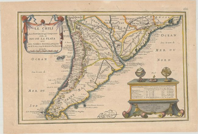
Title:
“Le Chili et les Provinces qui Composent Celles de Rio de la Plata avec les Terres Magellanique”
Map Maker:
Nicolas de Fer
This map shows detail mostly confined along the co... (full text available to subscribers)
| Item Detail |
| |
| |
MapMaker: |
Nicolas de Fer
|
|
| |
| |
Subject: |
Southern South America |
|
| |
Period/Size: |
1705 / 8.6" x 13.3" (21.9 x 33.8 cm)
|
|
| |
Color: |
Colored
|
|
| |
Condition: |
(B+) Light toning and minor soiling with a short printer's crease at top right. (condition help) |
|
| |
Source: |
L'Atlas Curieux ou le Monde |
|
| |
References: |
Pastoureau, FER I [114]. |
|
| |
|
|
| Sales Information |
| |
| |
Price: |
|
|
| |
| |
Offered by: |
Old World Auctions |
|
| |
Catalog: |
Auction No. 172 - Antique Maps, Charts, Atlases & Globes (9470) |
|
| |
Lot/Item #: |
362 |
|
| |
| |
Date: |
04/2019
|
|
| |
| |
|
Antique Maps - Valuation and Pricing, Descriptions, Resources |
|
Home |
Information |
Search |
Register |
Contact Us |
Site Map
Americana Exchange, Inc. © 1999 - 2024 Americana Exchange, Inc.. All rights reserved.
OldMaps.com, the OldMaps.com logo and
AMPR are service marks or registered service marks of Americana Exchange, Inc..
|