Title:
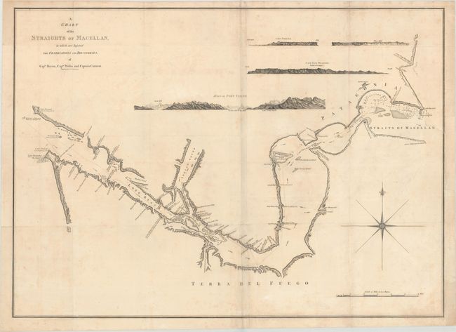
“A Chart of the Straights of Magellan, in Which Are Inserted the Observations and Discoveries, of Captn. Byron, Captn. Wallis and Captain Carteret”
Map Maker:
John Russell
Striking large-scale chart showing the Straits of ... (full text available to subscribers)
| Item Detail |
| |
| |
MapMaker: |
John Russell
|
|
| |
| |
Subject: |
Strait of Magellan |
|
| |
Period/Size: |
1768 / 22.3" x 31.0" (56.7 x 78.8 cm)
|
|
| |
Color: |
Black & White
|
|
| |
Condition: |
(B+) A good impression on a sheet with folds as issued. There is light soiling and faint foxing. A binding trim at right has been replaced with old paper, and an adjacent binding tear that enters about 1.5" into map has been archivally repaired. Tissue (condition help) |
|
| |
Source: |
|
|
| |
References: |
|
|
| |
|
|
| Sales Information |
| |
| |
Price: |
|
|
| |
| |
Offered by: |
Old World Auctions |
|
| |
Catalog: |
Auction No. 172 - Antique Maps, Charts, Atlases & Globes (9470) |
|
| |
Lot/Item #: |
367 |
|
| |
| |
Date: |
04/2019
|
|
| |
| |
|
Antique Maps - Valuation and Pricing, Descriptions, Resources |
|
Home |
Information |
Search |
Register |
Contact Us |
Site Map
Americana Exchange, Inc. © 1999 - 2024 Americana Exchange, Inc.. All rights reserved.
OldMaps.com, the OldMaps.com logo and
AMPR are service marks or registered service marks of Americana Exchange, Inc..
|