Title:
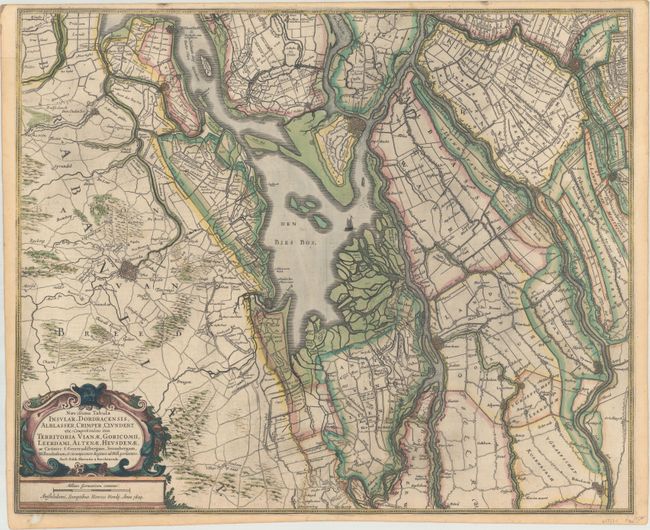
“Novissima Tabula Insular. Dordracensis, Alblasser, Crimper, Clundert Etc: Comprehendens Item Territoria Vianae, Goricomii, Leerdami, Altenae, Heusdenae...”
Map Maker:
Henricus Hondius
This handsome map of the southern part of the Neth... (full text available to subscribers)
| Item Detail |
| |
| |
MapMaker: |
Henricus Hondius
|
|
| |
| |
Subject: |
Southern Netherlands |
|
| |
Period/Size: |
1629 / 17.6" x 21.6" (44.7 x 54.9 cm)
|
|
| |
Color: |
Colored
|
|
| |
Condition: |
(B+) A sharp impression with a couple light spots, some printer's ink residue, and a short edge tear that enters 0.5" into image at bottom center that has been closed on verso with archival materials. There is a small hole at bottom left that just touche (condition help) |
|
| |
Source: |
|
|
| |
References: |
Van der Krogt (Vol. I) #3403:1.1. |
|
| |
|
|
| Sales Information |
| |
| |
Price: |
|
|
| |
| |
Offered by: |
Old World Auctions |
|
| |
Catalog: |
Auction No. 172 - Antique Maps, Charts, Atlases & Globes (9470) |
|
| |
Lot/Item #: |
430 |
|
| |
| |
Date: |
04/2019
|
|
| |
| |
|
Antique Maps - Valuation and Pricing, Descriptions, Resources |
|
Home |
Information |
Search |
Register |
Contact Us |
Site Map
Americana Exchange, Inc. © 1999 - 2024 Americana Exchange, Inc.. All rights reserved.
OldMaps.com, the OldMaps.com logo and
AMPR are service marks or registered service marks of Americana Exchange, Inc..
|