Title:
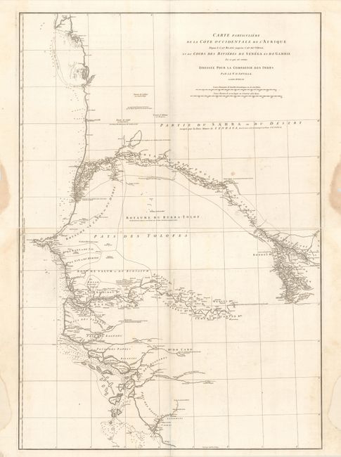
“Carte Particuliere de la Cote Occidentale de l'Afrique Depuis le Cap Blanc Jusqu'au Cap de Verga, et du Cours des Rivieres de Senega et de Gambie…”
Map Maker:
Jean Baptiste Bourguignon d' Anville
Printed on two elephant folio sheets, this map dep... (full text available to subscribers)
| Item Detail |
| |
| |
MapMaker: |
Jean Baptiste Bourguignon d' Anville
|
|
| |
| |
Subject: |
Western Africa |
|
| |
Period/Size: |
1751 / 19.8" x 27.6" (50.3 x 70.1 cm)
|
|
| |
Color: |
Black & White
|
|
| |
Condition: |
(B+) Dark impressions on watermarked paper with faint offsetting and a few minor spots in the image. The top sheet has dampstains confined to the side margins, while the lower sheet has some side margin reinstatement. Please note that the first image is (condition help) |
|
| |
Source: |
|
|
| |
References: |
Shirley (BL Atlases) T-ANV-2a #30-31. |
|
| |
|
|
| Sales Information |
| |
| |
Price: |
|
|
| |
| |
Offered by: |
Old World Auctions |
|
| |
Catalog: |
Auction No. 172 - Antique Maps, Charts, Atlases & Globes (9470) |
|
| |
Lot/Item #: |
690 |
|
| |
| |
Date: |
04/2019
|
|
| |
| |
|
Antique Maps - Valuation and Pricing, Descriptions, Resources |
|
Home |
Information |
Search |
Register |
Contact Us |
Site Map
Americana Exchange, Inc. © 1999 - 2024 Americana Exchange, Inc.. All rights reserved.
OldMaps.com, the OldMaps.com logo and
AMPR are service marks or registered service marks of Americana Exchange, Inc..
|