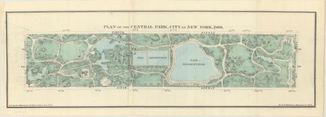
Title:
“Plan of the Central Park, City of New York, 1860”
Map Maker:
George Hayward
This attractive plan of Central Park was issued in... (full text available to subscribers)
| Item Detail |
| |
| |
MapMaker: |
George Hayward
|
|
| |
| |
Subject: |
New York City, New York |
|
| |
Period/Size: |
1860 / 5.6" x 18.1" (14.3 x 46.0 cm)
|
|
| |
Color: |
Colored
|
|
| |
Condition: |
(A) Issued folding with a hint of offsetting. (condition help) |
|
| |
Source: |
Valentine's Manual |
|
| |
References: |
|
|
| |
|
|
| Sales Information |
| |
| |
Price: |
|
|
| |
| |
Offered by: |
Old World Auctions |
|
| |
Catalog: |
Auction No. 173 - Antique Maps, Charts, Atlases & Globes (9471) |
|
| |
Lot/Item #: |
148 |
|
| |
| |
Date: |
06/2019
|
|
| |
| |
|
Antique Maps - Valuation and Pricing, Descriptions, Resources |
|
Home |
Information |
Search |
Register |
Contact Us |
Site Map
Americana Exchange, Inc. © 1999 - 2024 Americana Exchange, Inc.. All rights reserved.
OldMaps.com, the OldMaps.com logo and
AMPR are service marks or registered service marks of Americana Exchange, Inc..
|