Rister or Sign In to see pricing information


Title:

Chart of Hudson's Strait & Sir Thos. Rowe's Welcome Shewing the Track & Discoveries of H.M.S. Griper in an Attempt to Reach Repulse Bay by the Welcome A.D. 1824...

Map Maker:

John Murray

Chart of Hudson's Strait & Sir Thos. Rowe's Welcome Shewing the Track & Discoveries of H.M.S. Griper in an Attempt to Reach Repulse Bay by the Welcome A.D. 1824...

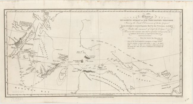
This detailed chart chronicles the track of the H.... (full text available to subscribers)
Item Detail
 
  MapMaker:  

John Murray


  Subject:  Eastern Canada, Hudson Bay  
  Period/Size:  1825 / 7.0" x 14.3"  (17.8 x 36.4 cm)  
  Color:  Black & White  
  Condition:  (A) Issued folding with some minor extraneous creasing. (condition help)  
  Source:  A Brief Narrative of an Unsuccessful Attempt to Reach Repulse Bay…  
  References:   
 
 
Sales Information
 
  Price: 

Please register your email to view records, or sign in with email address to see records


  Offered by:  Old World Auctions  
  Catalog:  Auction No. 173 - Antique Maps, Charts, Atlases & Globes (9471)  
  Lot/Item #:  69  
 
  Date:  06/2019  


Antique Maps - Valuation and Pricing, Descriptions, Resources


Home | Information | Search | Register | Contact Us | Site Map

Americana Exchange, Inc. © 1999 - 2024 Americana Exchange, Inc.. All rights reserved. OldMaps.com, the OldMaps.com logo and
AMPR are service marks or registered service marks of Americana Exchange, Inc..