Title:
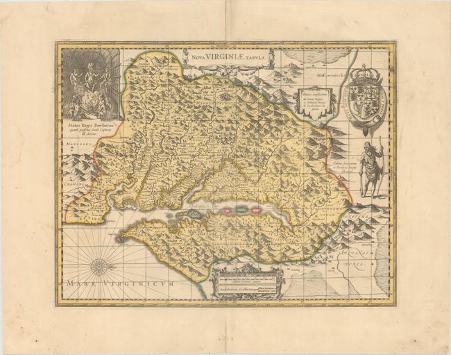
“Nova Virginiae Tabula”
Map Maker:
Hondius/Valk & Schenk
This graphic map is Henricus Hondius' version of C... (full text available to subscribers)
| Item Detail |
| |
| |
MapMaker: |
Hondius/Valk & Schenk
|
|
| |
| |
Subject: |
Colonial Mid-Atlantic United States |
|
| |
Period/Size: |
1700 / 14.8" x 19.2" (37.6 x 48.8 cm)
|
|
| |
Color: |
Colored
|
|
| |
Condition: |
(B+) A nice impression with contemporary color on a sheet watermarked with "P Schenk." There is marginal soiling and archival repairs to two tiny tears in the image at top center and to centerfold separations confined to the blank margins. (condition help) |
|
| |
Source: |
|
|
| |
References: |
Burden #228; Tooley (Amer) pp. 165-66; Van der Krogt (Vol. I) #9410:1. |
|
| |
|
|
| Sales Information |
| |
| |
Price: |
|
|
| |
| |
Offered by: |
Old World Auctions |
|
| |
Catalog: |
Auction No. 173 - Antique Maps, Charts, Atlases & Globes (9471) |
|
| |
Lot/Item #: |
95 |
|
| |
| |
Date: |
06/2019
|
|
| |
| |
|
Antique Maps - Valuation and Pricing, Descriptions, Resources |
|
Home |
Information |
Search |
Register |
Contact Us |
Site Map
Americana Exchange, Inc. © 1999 - 2024 Americana Exchange, Inc.. All rights reserved.
OldMaps.com, the OldMaps.com logo and
AMPR are service marks or registered service marks of Americana Exchange, Inc..
|