Title:
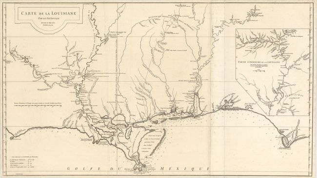
“Carte de la Louisiane par Le Sr. D'Anville Dressee en Mai 1732. Publiee en 1752.”
Map Maker:
Jean Baptiste Bourguignon d' Anville
This large and graphic map is one of the earliest ... (full text available to subscribers)
| Item Detail |
| |
| |
MapMaker: |
Jean Baptiste Bourguignon d' Anville
|
|
| |
| |
Subject: |
Colonial Southern United States |
|
| |
Period/Size: |
1752 / 20.4" x 36.4" (51.9 x 92.5 cm)
|
|
| |
Color: |
Black & White
|
|
| |
Condition: |
(A) A dark impression with a few faint spots and a hint of toning in the left two-thirds of the sheet. (condition help) |
|
| |
Source: |
|
|
| |
References: |
Phillips (Atlases) #571-35; Lemmon, Magill & Wiese #24. |
|
| |
|
|
| Sales Information |
| |
| |
Price: |
|
|
| |
| |
Offered by: |
Old World Auctions |
|
| |
Catalog: |
Auction No. 173 - Antique Maps, Charts, Atlases & Globes (9471) |
|
| |
Lot/Item #: |
105 |
|
| |
| |
Date: |
06/2019
|
|
| |
| |
|
Antique Maps - Valuation and Pricing, Descriptions, Resources |
|
Home |
Information |
Search |
Register |
Contact Us |
Site Map
Americana Exchange, Inc. © 1999 - 2024 Americana Exchange, Inc.. All rights reserved.
OldMaps.com, the OldMaps.com logo and
AMPR are service marks or registered service marks of Americana Exchange, Inc..
|