Title:
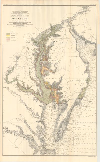
“Map Showing the General Location of the Natural Oyster Grounds of Maryland...”
Map Maker:
U.S. Government
This colorful chart details oyster fishing beds th... (full text available to subscribers)
| Item Detail |
| |
| |
MapMaker: |
U.S. Government
|
|
| |
| |
Subject: |
Maryland |
|
| |
Period/Size: |
1893 / 35.3" x 21.9" (89.7 x 55.7 cm)
|
|
| |
Color: |
Colored
|
|
| |
Condition: |
(A) Issued folding with a hint of toning. The gray areas at the top of the map image are caused by our scanner and not on the physical map itself. (condition help) |
|
| |
Source: |
Bulletin of the United States Fish Commission |
|
| |
References: |
|
|
| |
|
|
| Sales Information |
| |
| |
Price: |
|
|
| |
| |
Offered by: |
Old World Auctions |
|
| |
Catalog: |
Auction No. 173 - Antique Maps, Charts, Atlases & Globes (9471) |
|
| |
Lot/Item #: |
141 |
|
| |
| |
Date: |
06/2019
|
|
| |
| |
|
Antique Maps - Valuation and Pricing, Descriptions, Resources |
|
Home |
Information |
Search |
Register |
Contact Us |
Site Map
Americana Exchange, Inc. © 1999 - 2024 Americana Exchange, Inc.. All rights reserved.
OldMaps.com, the OldMaps.com logo and
AMPR are service marks or registered service marks of Americana Exchange, Inc..
|