Title:
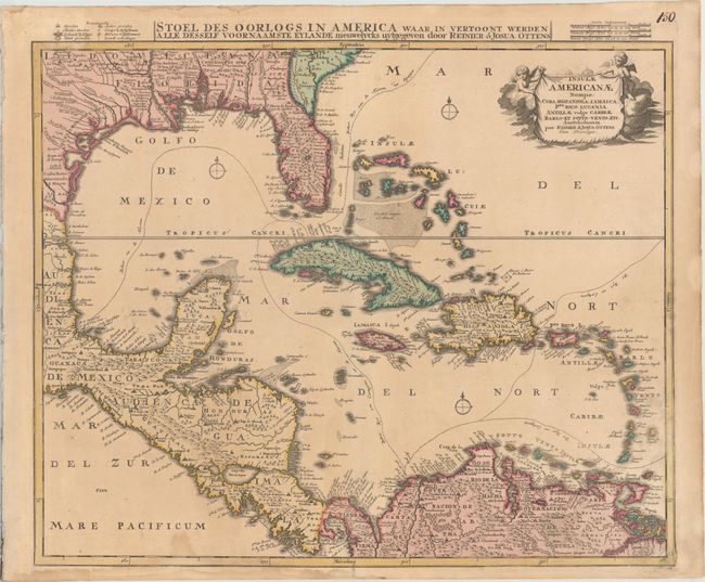
“Insulae Americanae Nempe: Cuba, Hispaniola. Jamaica. Pto Rico. Lucania. Antillae Vulgo Caribae. Barlo-Et Sotto-Vento. Etc.”
Map Maker:
Reiner and Joshua Ottens
The Ottens brothers based this map of the West Ind... (full text available to subscribers)
| Item Detail |
| |
| |
MapMaker: |
Reiner and Joshua Ottens
|
|
| |
| |
Subject: |
Gulf of Mexico & Caribbean |
|
| |
Period/Size: |
1730 / 19.4" x 22.6" (49.3 x 57.4 cm)
|
|
| |
Color: |
Colored
|
|
| |
Condition: |
(B+) A nice impression with contemporary color on a sturdy sheet with light toning and some damp stains at bottom, entering the image just below the word "Pacificum." (condition help) |
|
| |
Source: |
|
|
| |
References: |
cf. Manasek #64. |
|
| |
|
|
| Sales Information |
| |
| |
Price: |
|
|
| |
| |
Offered by: |
Old World Auctions |
|
| |
Catalog: |
Auction No. 173 - Antique Maps, Charts, Atlases & Globes (9471) |
|
| |
Lot/Item #: |
188 |
|
| |
| |
Date: |
06/2019
|
|
| |
| |
|
Antique Maps - Valuation and Pricing, Descriptions, Resources |
|
Home |
Information |
Search |
Register |
Contact Us |
Site Map
Americana Exchange, Inc. © 1999 - 2024 Americana Exchange, Inc.. All rights reserved.
OldMaps.com, the OldMaps.com logo and
AMPR are service marks or registered service marks of Americana Exchange, Inc..
|