Title:
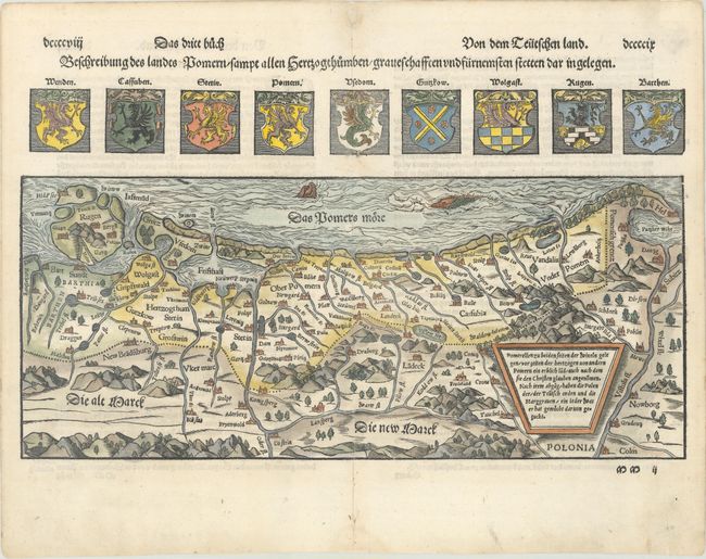
“Beschreibung des Landts Pomern / Sampt Allen Hertzogthumben / Graueschafften und Furnemsten Stetten dar in Gelegen”
Map Maker:
Sebastian Munster
This is a very interesting woodblock map of the hi... (full text available to subscribers)
| Item Detail |
| |
| |
MapMaker: |
Sebastian Munster
|
|
| |
| |
Subject: |
Northern Poland & Northeastern Germany |
|
| |
Period/Size: |
1556 / 9.6" x 15.0" (24.4 x 38.1 cm)
|
|
| |
Color: |
Colored
|
|
| |
Condition: |
(A) An excellent crisp impression with attractive later color and marginal soiling. There are professional repairs to a centerfold separation at bottom and a small hole at top, both confined to the blank margins. Remnants of hinge tape on verso. (condition help) |
|
| |
Source: |
Cosmographia |
|
| |
References: |
Shirley (BL Atlases) T.MUN-1f #96. |
|
| |
|
|
| Sales Information |
| |
| |
Price: |
|
|
| |
| |
Offered by: |
Old World Auctions |
|
| |
Catalog: |
Auction No. 173 - Antique Maps, Charts, Atlases & Globes (9471) |
|
| |
Lot/Item #: |
297 |
|
| |
| |
Date: |
06/2019
|
|
| |
| |
|
Antique Maps - Valuation and Pricing, Descriptions, Resources |
|
Home |
Information |
Search |
Register |
Contact Us |
Site Map
Americana Exchange, Inc. © 1999 - 2024 Americana Exchange, Inc.. All rights reserved.
OldMaps.com, the OldMaps.com logo and
AMPR are service marks or registered service marks of Americana Exchange, Inc..
|