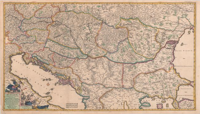
Title:
“Regni Hungariae, et Regionum, quae ei Quondam Fuere Unitae, ut Transilvaniae, Valachiae, Moldaviae, Serviae, Romaniae, Bulgariae, Bessarabiae, Croatiae, Bosniae, Dalmatiae, Sclavoniae, Morlachiae, Ragusanae Reipublicae...”
Map Maker:
Frederick de Wit
This large-scale map shows the Kingdom of Hungary ... (full text available to subscribers)
| Item Detail |
| |
| |
MapMaker: |
Frederick de Wit
|
|
| |
| |
Subject: |
Southeastern Europe, Hungary |
|
| |
Period/Size: |
1688 / 19.7" x 34.9" (50.1 x 88.7 cm)
|
|
| |
Color: |
Colored
|
|
| |
Condition: |
(B+) A fine impression with several long tears that have been professionally repaired with archival materials on verso, light toning, and some minor spots. (condition help) |
|
| |
Source: |
|
|
| |
References: |
|
|
| |
|
|
| Sales Information |
| |
| |
Price: |
|
|
| |
| |
Offered by: |
Old World Auctions |
|
| |
Catalog: |
Auction No. 173 - Antique Maps, Charts, Atlases & Globes (9471) |
|
| |
Lot/Item #: |
323 |
|
| |
| |
Date: |
06/2019
|
|
| |
| |
|
Antique Maps - Valuation and Pricing, Descriptions, Resources |
|
Home |
Information |
Search |
Register |
Contact Us |
Site Map
Americana Exchange, Inc. © 1999 - 2024 Americana Exchange, Inc.. All rights reserved.
OldMaps.com, the OldMaps.com logo and
AMPR are service marks or registered service marks of Americana Exchange, Inc..
|