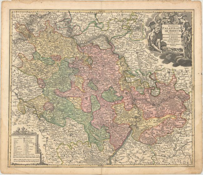
Title:
“Exactissima Palatinatus ad Rhenum Tabula, in qua Episcopatus Wormaciensis et Spirensis Ducatus Bipontinus...”
Map Maker:
Johann Baptist Homann
A striking regional map of Germany, centered on th... (full text available to subscribers)
| Item Detail |
| |
| |
MapMaker: |
Johann Baptist Homann
|
|
| |
| |
Subject: |
Western Germany |
|
| |
Period/Size: |
1715 / 19.4" x 22.8" (49.3 x 58.0 cm)
|
|
| |
Color: |
Colored
|
|
| |
Condition: |
(B+) Contemporary color with an old paper repair on a centerfold separation that enters 3.5" into image at bottom and light damp stains along the edges of the sheet, entering the border in the bottom corners. (condition help) |
|
| |
Source: |
|
|
| |
References: |
|
|
| |
|
|
| Sales Information |
| |
| |
Price: |
|
|
| |
| |
Offered by: |
Old World Auctions |
|
| |
Catalog: |
Auction No. 175 - Antique Maps, Charts, Atlases & Globes (9482) |
|
| |
Lot/Item #: |
451 |
|
| |
| |
Date: |
11/2019
|
|
| |
| |
|
Antique Maps - Valuation and Pricing, Descriptions, Resources |
|
Home |
Information |
Search |
Register |
Contact Us |
Site Map
Americana Exchange, Inc. © 1999 - 2024 Americana Exchange, Inc.. All rights reserved.
OldMaps.com, the OldMaps.com logo and
AMPR are service marks or registered service marks of Americana Exchange, Inc..
|