Title:
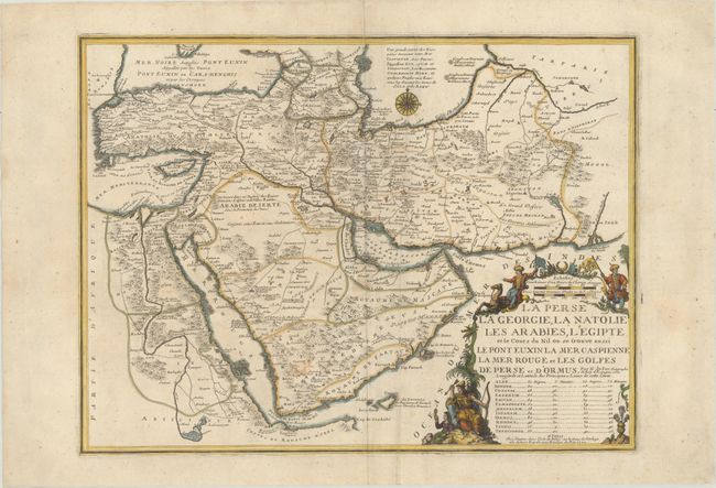
“La Perse la Georgie, la Natolie les Arabies, l'Egipte et le Cours du Nil ou se Trouve Aussi le Pont Euxin la Mer Caspienne la Mer Rouge et les Golfes de Perse et d'Ormus”
Map Maker:
Nicolas de Fer
This detailed map of Persia, Anatolia, the Arabian... (full text available to subscribers)
| Item Detail |
| |
| |
MapMaker: |
Nicolas de Fer
|
|
| |
| |
Subject: |
Middle East |
|
| |
Period/Size: |
1720 / 16.4" x 22.0" (41.7 x 55.9 cm)
|
|
| |
Color: |
Colored
|
|
| |
Condition: |
(B+) A nice impression with wide margins and a few small stains in map image. (condition help) |
|
| |
Source: |
Atlas ou Recueil de Cartes Geographiques |
|
| |
References: |
Ankary #140; Pastoureau, FER II B. |
|
| |
|
|
| Sales Information |
| |
| |
Price: |
|
|
| |
| |
Offered by: |
Old World Auctions |
|
| |
Catalog: |
Auction No. 175 - Antique Maps, Charts, Atlases & Globes (9482) |
|
| |
Lot/Item #: |
540 |
|
| |
| |
Date: |
11/2019
|
|
| |
| |
|
Antique Maps - Valuation and Pricing, Descriptions, Resources |
|
Home |
Information |
Search |
Register |
Contact Us |
Site Map
Americana Exchange, Inc. © 1999 - 2024 Americana Exchange, Inc.. All rights reserved.
OldMaps.com, the OldMaps.com logo and
AMPR are service marks or registered service marks of Americana Exchange, Inc..
|