Title:
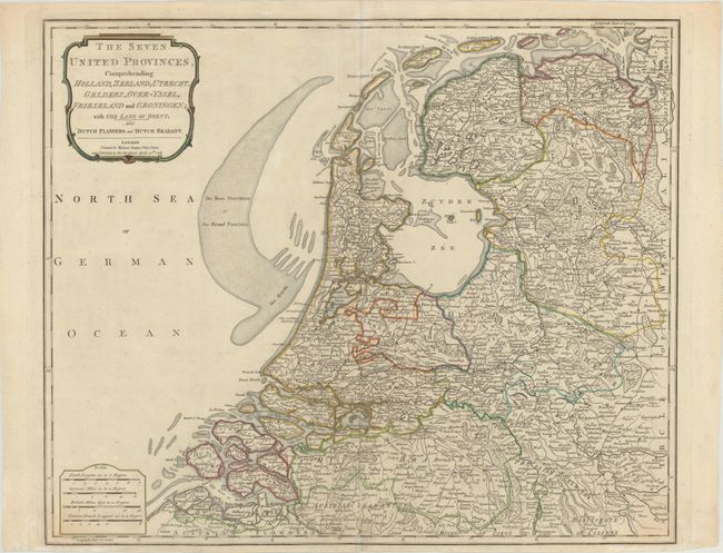
“The Seven United Provinces, Comprehending Holland, Zeeland, Utrecht, Gelders, Over-Yssel, Frieseland and Groningen; with the Land of Drent; Also Dutch Flanders and Dutch Brabant”
Map Maker:
Robert Sayer
This densely engraved map of the Netherlands exten... (full text available to subscribers)
| Item Detail |
| |
| |
MapMaker: |
Robert Sayer
|
|
| |
| |
Subject: |
Netherlands |
|
| |
Period/Size: |
1788 / 18.7" x 22.7" (47.5 x 57.7 cm)
|
|
| |
Color: |
Colored
|
|
| |
Condition: |
(B+) A fine impression on paper with a large fleur-de-lis coat of arms watermark and an archivally repaired centerfold separation that enters 4" into map at bottom. The bottom margin is narrow, but ample for framing. (condition help) |
|
| |
Source: |
Describing the ... Universe |
|
| |
References: |
|
|
| |
|
|
| Sales Information |
| |
| |
Price: |
|
|
| |
| |
Offered by: |
Old World Auctions |
|
| |
Catalog: |
Auction No. 175 - Antique Maps, Charts, Atlases & Globes (9482) |
|
| |
Lot/Item #: |
396 |
|
| |
| |
Date: |
11/2019
|
|
| |
| |
|
Antique Maps - Valuation and Pricing, Descriptions, Resources |
|
Home |
Information |
Search |
Register |
Contact Us |
Site Map
Americana Exchange, Inc. © 1999 - 2024 Americana Exchange, Inc.. All rights reserved.
OldMaps.com, the OldMaps.com logo and
AMPR are service marks or registered service marks of Americana Exchange, Inc..
|