Title:
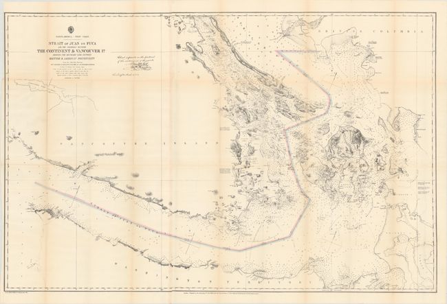
“Strait of Juan de Fuca and the Channels Between the Continent & Vancouver Id. Showing the Boundary Line Between British & American Possessions”
Map Maker:
U.S. Hydrographic Office
This detailed chart, joined on two sheets, is the ... (full text available to subscribers)
| Item Detail |
| |
| |
MapMaker: |
U.S. Hydrographic Office
|
|
| |
| |
Subject: |
Washington & British Columbia |
|
| |
Period/Size: |
1872 / 28.8" x 44.3" (73.2 x 112.6 cm)
|
|
| |
Color: |
Colored
|
|
| |
Condition: |
(B+) Issued folding with light toning along the fold lines and a number of tiny splits at fold junctions. A 2" fold separation along the lower right fold has been closed on verso with archival tape. (condition help) |
|
| |
Source: |
|
|
| |
References: |
|
|
| |
|
|
| Sales Information |
| |
| |
Price: |
|
|
| |
| |
Offered by: |
Old World Auctions |
|
| |
Catalog: |
Auction No. 175 - Antique Maps, Charts, Atlases & Globes (9482) |
|
| |
Lot/Item #: |
104 |
|
| |
| |
Date: |
11/2019
|
|
| |
| |
|
Antique Maps - Valuation and Pricing, Descriptions, Resources |
|
Home |
Information |
Search |
Register |
Contact Us |
Site Map
Americana Exchange, Inc. © 1999 - 2024 Americana Exchange, Inc.. All rights reserved.
OldMaps.com, the OldMaps.com logo and
AMPR are service marks or registered service marks of Americana Exchange, Inc..
|