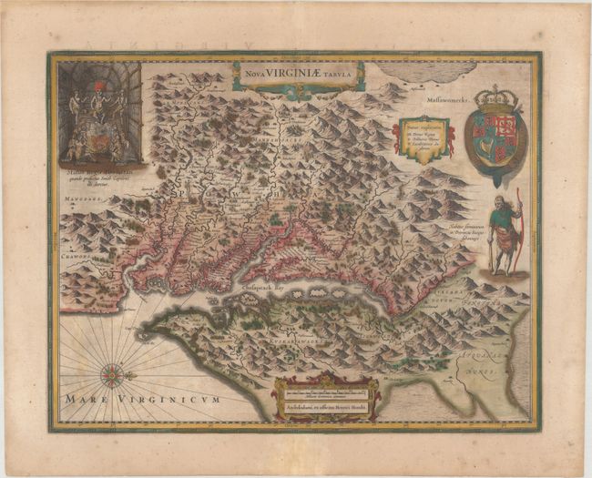
Title:
“Nova Virginiae Tabula”
Map Maker:
Henricus Hondius
This graphic map is Henricus Hondius' version of C... (full text available to subscribers)
| Item Detail |
| |
| |
MapMaker: |
Henricus Hondius
|
|
| |
| |
Subject: |
Colonial Mid-Atlantic United States |
|
| |
Period/Size: |
1647 / 15.0" x 19.4" (38.1 x 49.3 cm)
|
|
| |
Color: |
Colored
|
|
| |
Condition: |
(B) A nice impression with full contemporary color that has been partially refreshed and light toning and staining. This map will ship flat. (condition help) |
|
| |
Source: |
Atlas Novus |
|
| |
References: |
Burden #228; Tooley (Amer) pp. 165-66; Van der Krogt (Vol. I) #9410:1. |
|
| |
|
|
| Sales Information |
| |
| |
Price: |
|
|
| |
| |
Offered by: |
Old World Auctions |
|
| |
Catalog: |
Auction No. 175 - Antique Maps, Charts, Atlases & Globes (9482) |
|
| |
Lot/Item #: |
126 |
|
| |
| |
Date: |
11/2019
|
|
| |
| |
|
Antique Maps - Valuation and Pricing, Descriptions, Resources |
|
Home |
Information |
Search |
Register |
Contact Us |
Site Map
Americana Exchange, Inc. © 1999 - 2024 Americana Exchange, Inc.. All rights reserved.
OldMaps.com, the OldMaps.com logo and
AMPR are service marks or registered service marks of Americana Exchange, Inc..
|