Title:
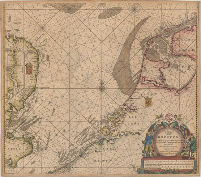
“Pas Caerte van Texel tot aende Hoofden; Begrypende in sich de Zee-Custen van Vries-Land, Holland, Zeeland, Flaenderen; ende Oost-Cust van Engeland”
Map Maker:
Johannes van Keulen
This handsome coastal chart details the North Sea ... (full text available to subscribers)
| Item Detail |
| |
| |
MapMaker: |
Johannes van Keulen
|
|
| |
| |
Subject: |
North Sea |
|
| |
Period/Size: |
1680 / 20.4" x 23.3" (51.9 x 59.2 cm)
|
|
| |
Color: |
Colored
|
|
| |
Condition: |
(B+) A dark impression printed on a double-thick sheet with light foxing, toning along the edges of the sheet, and a tiny centerfold separation at bottom. (condition help) |
|
| |
Source: |
|
|
| |
References: |
|
|
| |
|
|
| Sales Information |
| |
| |
Price: |
|
|
| |
| |
Offered by: |
Old World Auctions |
|
| |
Catalog: |
Auction No. 175 - Antique Maps, Charts, Atlases & Globes (9482) |
|
| |
Lot/Item #: |
382 |
|
| |
| |
Date: |
11/2019
|
|
| |
| |
|
Antique Maps - Valuation and Pricing, Descriptions, Resources |
|
Home |
Information |
Search |
Register |
Contact Us |
Site Map
Americana Exchange, Inc. © 1999 - 2024 Americana Exchange, Inc.. All rights reserved.
OldMaps.com, the OldMaps.com logo and
AMPR are service marks or registered service marks of Americana Exchange, Inc..
|