Rister or Sign In to see pricing information


Title:

Kaart van het Westelyk Gedeelte van Nieuw Mexico en van California Volgens de Laatste Ontdekkingen der Jesuiten en Anderen

Map Maker:

Isaac Tirion

Kaart van het Westelyk Gedeelte van Nieuw Mexico en van California Volgens de Laatste Ontdekkingen der Jesuiten en Anderen

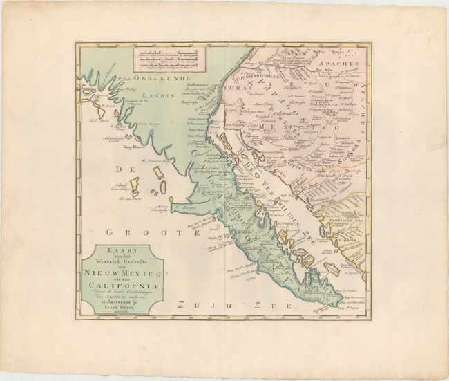
This bold map of Baja California and the American ... (full text available to subscribers)
Item Detail
 
  MapMaker:  

Isaac Tirion


  Subject:  Southwestern United States & Mexico  
  Period/Size:  1765 / 12.6" x 13.5"  (32.0 x 34.3 cm)  
  Color:  Colored  
  Condition:  (A) A nice impression with contemporary color on a strong sheet of paper with a fleur-de-lis coat of arms watermark and wide margins. There are a few minor spots of foxing, else near fine. (condition help)  
  Source:  Nieuwe en Beknopte Hand Atlas  
  References:  Lowery #498; Wagner #608; Wheat [TMW] #148.  
 
 
Sales Information
 
  Price: 

Please register your email to view records, or sign in with email address to see records


  Offered by:  Old World Auctions  
  Catalog:  Auction No. 175 - Antique Maps, Charts, Atlases & Globes (9482)  
  Lot/Item #:  255  
 
  Date:  11/2019  


Antique Maps - Valuation and Pricing, Descriptions, Resources


Home | Information | Search | Register | Contact Us | Site Map

Americana Exchange, Inc. © 1999 - 2024 Americana Exchange, Inc.. All rights reserved. OldMaps.com, the OldMaps.com logo and
AMPR are service marks or registered service marks of Americana Exchange, Inc..