Title:
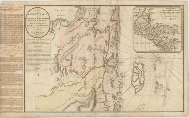
“A Map of a Part of Yucatan, or of That Part of the Eastern Shore Within the Bay of Honduras Alloted to Great Britain for the Cutting of Logwood...”
Map Maker:
William Faden
This impressive, large map depicts the coastline o... (full text available to subscribers)
| Item Detail |
| |
| |
MapMaker: |
William Faden
|
|
| |
| |
Subject: |
Belize |
|
| |
Period/Size: |
1787 / 20.7" x 30.8" (52.6 x 78.3 cm)
|
|
| |
Color: |
Colored
|
|
| |
Condition: |
(B) Moderate offsetting with some stains mostly in the right half of the sheet. There is one small hole in the map that has been archivally repaired. (condition help) |
|
| |
Source: |
|
|
| |
References: |
Kapp (MCC-106) #76. |
|
| |
|
|
| Sales Information |
| |
| |
Price: |
|
|
| |
| |
Offered by: |
Old World Auctions |
|
| |
Catalog: |
Auction No. 176 - Antique Maps, Charts, Atlases & Globes (9483) |
|
| |
Lot/Item #: |
289 |
|
| |
| |
Date: |
02/2020
|
|
| |
| |
|
Antique Maps - Valuation and Pricing, Descriptions, Resources |
|
Home |
Information |
Search |
Register |
Contact Us |
Site Map
Americana Exchange, Inc. © 1999 - 2024 Americana Exchange, Inc.. All rights reserved.
OldMaps.com, the OldMaps.com logo and
AMPR are service marks or registered service marks of Americana Exchange, Inc..
|