Title:
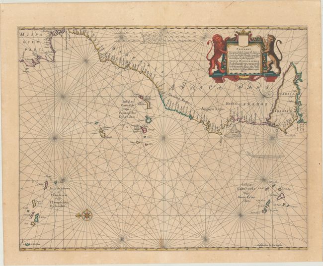
“Pascaart, Waer in Men Claarlyck Zien can alle Havens Rivieren Droogten Gelegen Tusschen C.S. Vincent en C. Verde... / Tabula Hydrographica uby Clarissime Perspicinutur Omnes Portus, Flu: et Vada Jacentia Inter Cap. S. Vincentii et Cap. Verde...”
Map Maker:
Jan Jansson
An attractive and uncommon chart covering the nort... (full text available to subscribers)
| Item Detail |
| |
| |
MapMaker: |
Jan Jansson
|
|
| |
| |
Subject: |
Northwestern Africa, Atlantic Islands |
|
| |
Period/Size: |
1650 / 16.5" x 21.1" (42.0 x 53.6 cm)
|
|
| |
Color: |
Colored
|
|
| |
Condition: |
(B+) Full contemporary color with light scattered foxing and a small stain at the bottom of the centerfold. A 2.5" tear adjacent to the Canary Islands has been professionally repaired on verso. (condition help) |
|
| |
Source: |
Nouvel Atlas, Vol. V |
|
| |
References: |
Van der Krogt (Vol. I) #0150:1. |
|
| |
|
|
| Sales Information |
| |
| |
Price: |
|
|
| |
| |
Offered by: |
Old World Auctions |
|
| |
Catalog: |
Auction No. 176 - Antique Maps, Charts, Atlases & Globes (9483) |
|
| |
Lot/Item #: |
658 |
|
| |
| |
Date: |
02/2020
|
|
| |
| |
|
Antique Maps - Valuation and Pricing, Descriptions, Resources |
|
Home |
Information |
Search |
Register |
Contact Us |
Site Map
Americana Exchange, Inc. © 1999 - 2024 Americana Exchange, Inc.. All rights reserved.
OldMaps.com, the OldMaps.com logo and
AMPR are service marks or registered service marks of Americana Exchange, Inc..
|