Title:
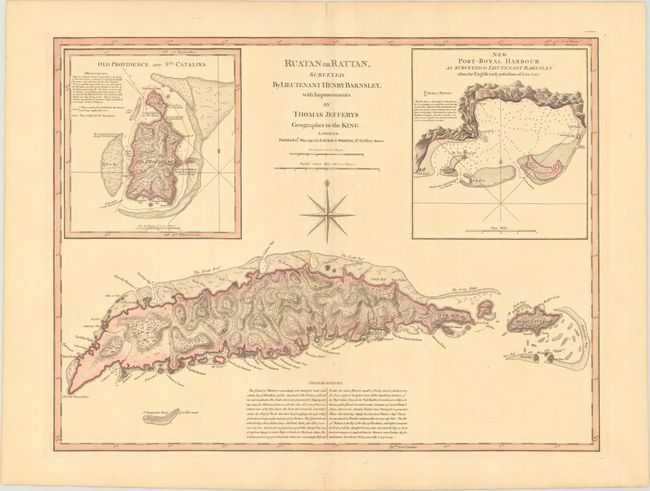
“Ruatan or Rattan, Surveyed by Lieutenant Henry Barnsley, with Improvements...”
Map Maker:
Jefferys/Laurie & Whittle
Finely engraved chart featuring the island of Ruat... (full text available to subscribers)
| Item Detail |
| |
| |
MapMaker: |
Jefferys/Laurie & Whittle
|
|
| |
| |
Subject: |
Roatan, Honduras |
|
| |
Period/Size: |
1794 / 18.2" x 24.1" (46.3 x 61.3 cm)
|
|
| |
Color: |
Colored
|
|
| |
Condition: |
(A) Contemporary color on a sturdy sheet with a hint of toning along the centerfold and short centerfold separations in the top and bottom blank margins. (condition help) |
|
| |
Source: |
The West-India Atlas |
|
| |
References: |
|
|
| |
|
|
| Sales Information |
| |
| |
Price: |
|
|
| |
| |
Offered by: |
Old World Auctions |
|
| |
Catalog: |
Auction No. 176 - Antique Maps, Charts, Atlases & Globes (9483) |
|
| |
Lot/Item #: |
290 |
|
| |
| |
Date: |
02/2020
|
|
| |
| |
|
Antique Maps - Valuation and Pricing, Descriptions, Resources |
|
Home |
Information |
Search |
Register |
Contact Us |
Site Map
Americana Exchange, Inc. © 1999 - 2024 Americana Exchange, Inc.. All rights reserved.
OldMaps.com, the OldMaps.com logo and
AMPR are service marks or registered service marks of Americana Exchange, Inc..
|