Title:
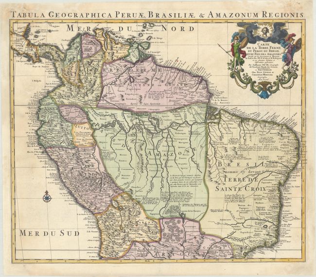
“Carte de la Terre Ferme du Perou, du Bresil et du Pays des Amazones, Dressee sur les Descriptions de Herrera de Laet, et des PP. d'Acuna, et M Rodriguez...”
Map Maker:
Delisle/Covens & Mortier
This handsome and important map of the northern pa... (full text available to subscribers)
| Item Detail |
| |
| |
MapMaker: |
Delisle/Covens & Mortier
|
|
| |
| |
Subject: |
Northern South America |
|
| |
Period/Size: |
1730 / 18.8" x 22.6" (47.8 x 57.4 cm)
|
|
| |
Color: |
Colored
|
|
| |
Condition: |
(B) A fine impression with contemporary color in the map and later color in the cartouche and a couple cracks caused by oxidation, the longest of which measures 6", that have been closed on verso with archival tape. There are light damp stains mostly con (condition help) |
|
| |
Source: |
|
|
| |
References: |
|
|
| |
|
|
| Sales Information |
| |
| |
Price: |
|
|
| |
| |
Offered by: |
Old World Auctions |
|
| |
Catalog: |
Auction No. 176 - Antique Maps, Charts, Atlases & Globes (9483) |
|
| |
Lot/Item #: |
331 |
|
| |
| |
Date: |
02/2020
|
|
| |
| |
|
Antique Maps - Valuation and Pricing, Descriptions, Resources |
|
Home |
Information |
Search |
Register |
Contact Us |
Site Map
Americana Exchange, Inc. © 1999 - 2024 Americana Exchange, Inc.. All rights reserved.
OldMaps.com, the OldMaps.com logo and
AMPR are service marks or registered service marks of Americana Exchange, Inc..
|