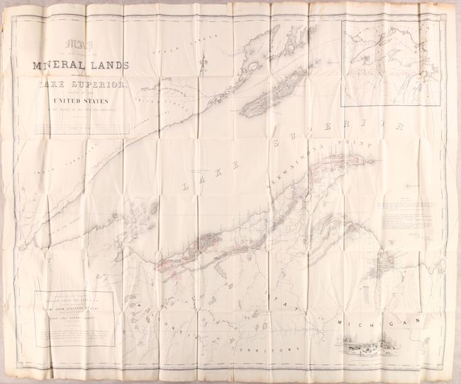
Title:
“Map of That Part of the Mineral Lands Adjacent to Lake Superior, Ceded to the United States by the Treaty of 1842 with the Chippewas”
Map Maker:
U.S. Government
The subtitle continues, "Comprising that District ... (full text available to subscribers)
| Item Detail |
| |
| |
MapMaker: |
U.S. Government
|
|
| |
| |
Subject: |
Michigan & Wisconsin |
|
| |
Period/Size: |
1845 / 35.6" x 44.8" (90.5 x 113.8 cm)
|
|
| |
Color: |
Colored
|
|
| |
Condition: |
(B+) Issued folding with some light scattered foxing mostly at top left. (condition help) |
|
| |
Source: |
Sen. Doc. 175, 28th Congress, 2nd Session |
|
| |
References: |
|
|
| |
|
|
| Sales Information |
| |
| |
Price: |
|
|
| |
| |
Offered by: |
Old World Auctions |
|
| |
Catalog: |
Auction No. 176 - Antique Maps, Charts, Atlases & Globes (9483) |
|
| |
Lot/Item #: |
223 |
|
| |
| |
Date: |
02/2020
|
|
| |
| |
|
Antique Maps - Valuation and Pricing, Descriptions, Resources |
|
Home |
Information |
Search |
Register |
Contact Us |
Site Map
Americana Exchange, Inc. © 1999 - 2024 Americana Exchange, Inc.. All rights reserved.
OldMaps.com, the OldMaps.com logo and
AMPR are service marks or registered service marks of Americana Exchange, Inc..
|