Title:
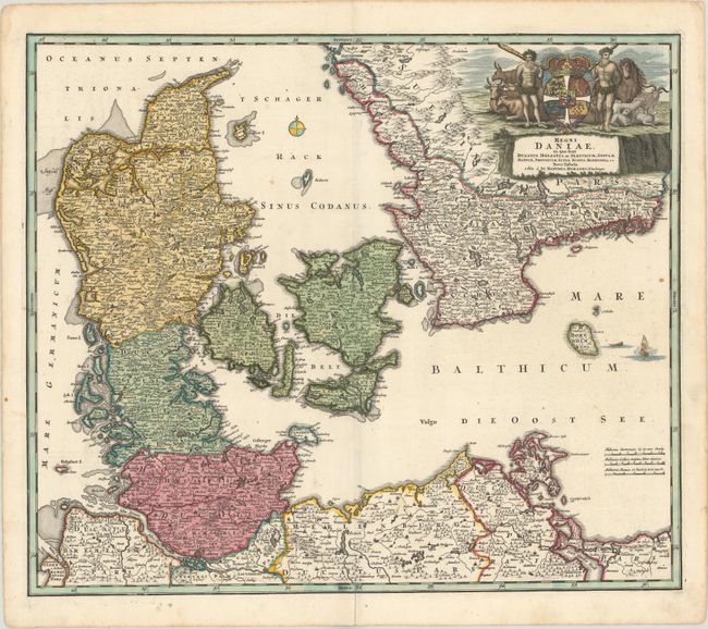
“Regni Daniae, in quo sunt Ducatus Holsatia et Slesvicum, Insulae Danicae, Provinciae Iutia Scania Blekingia &c Nova Tabula”
Map Maker:
Johann Baptist Homann
This magnificent map covers all of Denmark, the no... (full text available to subscribers)
| Item Detail |
| |
| |
MapMaker: |
Johann Baptist Homann
|
|
| |
| |
Subject: |
Denmark |
|
| |
Period/Size: |
1738 / 19.1" x 22.4" (48.6 x 56.9 cm)
|
|
| |
Color: |
Colored
|
|
| |
Condition: |
(A) A sharp impression on a bright sheet of watermarked paper with contemporary color in the map and later color in the cartouche. There are a few minor spots and an archivally repaired centerfold separation that enters 1" into image at bottom. (condition help) |
|
| |
Source: |
|
|
| |
References: |
|
|
| |
|
|
| Sales Information |
| |
| |
Price: |
|
|
| |
| |
Offered by: |
Old World Auctions |
|
| |
Catalog: |
Auction No. 176 - Antique Maps, Charts, Atlases & Globes (9483) |
|
| |
Lot/Item #: |
413 |
|
| |
| |
Date: |
02/2020
|
|
| |
| |
|
Antique Maps - Valuation and Pricing, Descriptions, Resources |
|
Home |
Information |
Search |
Register |
Contact Us |
Site Map
Americana Exchange, Inc. © 1999 - 2024 Americana Exchange, Inc.. All rights reserved.
OldMaps.com, the OldMaps.com logo and
AMPR are service marks or registered service marks of Americana Exchange, Inc..
|