Title:
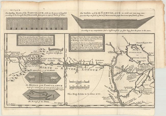
“A Map of ye Long River and of Some Others That Fall into That Finall Part of ye Great River of Missisipi Wich Is Here Laid Down...”
Map Maker:
Louis Armand de Lom d'Arce, de Lahontan
One of the most influential, and fanciful, maps in... (full text available to subscribers)
| Item Detail |
| |
| |
MapMaker: |
Louis Armand de Lom d'Arce, de Lahontan
|
|
| |
| |
Subject: |
Colonial Upper Midwestern United States, River Longue |
|
| |
Period/Size: |
1703 / 8.4" x 13.3" (21.4 x 33.8 cm)
|
|
| |
Color: |
Black & White
|
|
| |
Condition: |
(B+) Fine impression on thick paper with large unicorn watermark, folding as issued with a few short fold separations that have been archivally repaired and soiling along the edges of the sheet. There is a binding trim at right with an associated 3" bind (condition help) |
|
| |
Source: |
New Voyages to North America |
|
| |
References: |
Kershaw #306; Schwartz & Ehrenberg #81, p. 142. |
|
| |
|
|
| Sales Information |
| |
| |
Price: |
|
|
| |
| |
Offered by: |
Old World Auctions |
|
| |
Catalog: |
Auction No. 176 - Antique Maps, Charts, Atlases & Globes (9483) |
|
| |
Lot/Item #: |
157 |
|
| |
| |
Date: |
02/2020
|
|
| |
| |
|
Antique Maps - Valuation and Pricing, Descriptions, Resources |
|
Home |
Information |
Search |
Register |
Contact Us |
Site Map
Americana Exchange, Inc. © 1999 - 2024 Americana Exchange, Inc.. All rights reserved.
OldMaps.com, the OldMaps.com logo and
AMPR are service marks or registered service marks of Americana Exchange, Inc..
|