Title:
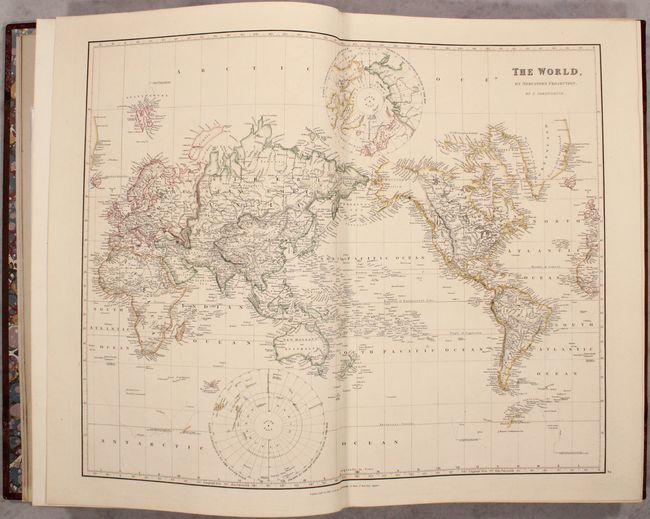
“The London Atlas of Universal Geography, Exhibiting the Physical & Political Divisions of the Various Countries of the World...”
Map Maker:
John Arrowsmith
This is considered to be one of the finest 19th ce... (full text available to subscribers)
| Item Detail |
| |
| |
MapMaker: |
John Arrowsmith
|
|
| |
| |
Subject: |
Atlases, World |
|
| |
Period/Size: |
1835 / 22.0" x 15.4" (55.9 x 39.2 cm)
|
|
| |
Color: |
Colored
|
|
| |
Condition: |
(A) Crisp impressions on sturdy sheets with occasional faint offsetting or a spot of foxing. There is light external wear with bumped edges. An attractive example. (condition help) |
|
| |
Source: |
|
|
| |
References: |
Phillips (Atlases) #764. |
|
| |
|
|
| Sales Information |
| |
| |
Price: |
|
|
| |
| |
Offered by: |
Old World Auctions |
|
| |
Catalog: |
Auction No. 176 - Antique Maps, Charts, Atlases & Globes (9483) |
|
| |
Lot/Item #: |
746 |
|
| |
| |
Date: |
02/2020
|
|
| |
| |
|
Antique Maps - Valuation and Pricing, Descriptions, Resources |
|
Home |
Information |
Search |
Register |
Contact Us |
Site Map
Americana Exchange, Inc. © 1999 - 2024 Americana Exchange, Inc.. All rights reserved.
OldMaps.com, the OldMaps.com logo and
AMPR are service marks or registered service marks of Americana Exchange, Inc..
|