Title:
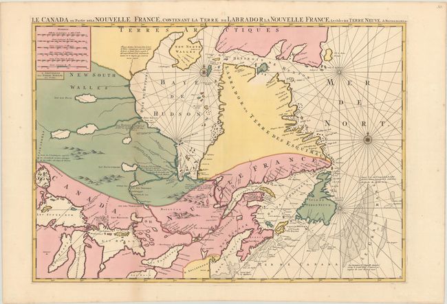
“Le Canada ou Partie de la Nouvelle France, Contenant la Terre de Labrador la Nouvelle France, les Isles de Terre Neuve. De Nostre Dame &c:”
Map Maker:
Pierre Mortier
First state of this large, striking map of the reg... (full text available to subscribers)
| Item Detail |
| |
| |
MapMaker: |
Pierre Mortier
|
|
| |
| |
Subject: |
Eastern Canada, Great Lakes |
|
| |
Period/Size: |
1693 / 21.5" x 30.8" (54.7 x 78.3 cm)
|
|
| |
Color: |
Colored
|
|
| |
Condition: |
(A+) An extremely fine copy in contemporary, full wash color on sturdy paper with a "P" watermark. (condition help) |
|
| |
Source: |
|
|
| |
References: |
Kershaw #176.I; Verner & Stuart Stubbs, #9. |
|
| |
|
|
| Sales Information |
| |
| |
Price: |
|
|
| |
| |
Offered by: |
Old World Auctions |
|
| |
Catalog: |
Auction No. 176 - Antique Maps, Charts, Atlases & Globes (9483) |
|
| |
Lot/Item #: |
80 |
|
| |
| |
Date: |
02/2020
|
|
| |
| |
|
Antique Maps - Valuation and Pricing, Descriptions, Resources |
|
Home |
Information |
Search |
Register |
Contact Us |
Site Map
Americana Exchange, Inc. © 1999 - 2024 Americana Exchange, Inc.. All rights reserved.
OldMaps.com, the OldMaps.com logo and
AMPR are service marks or registered service marks of Americana Exchange, Inc..
|