Title:
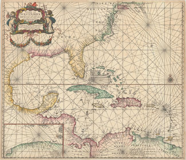
“Pascaerte van Westindien Begrypende in zich de Vaste Kusten en Eylanden, Alles op syn Waere Lengte en Breete op Wassende Graden Gelegt”
Map Maker:
Johannes van Keulen
Van Keulen's elegantly engraved sea chart of the G... (full text available to subscribers)
| Item Detail |
| |
| |
MapMaker: |
Johannes van Keulen
|
|
| |
| |
Subject: |
Gulf of Mexico & Caribbean |
|
| |
Period/Size: |
1681 / 20.4" x 23.6" (51.9 x 60.0 cm)
|
|
| |
Color: |
Colored
|
|
| |
Condition: |
(A) A crisp impression on a bright sheet with a small stain in the inset, an area of printer's ink residue south of Cuba, and a manuscript cross added adjacent to St. Croix. (condition help) |
|
| |
Source: |
Zee-Atlas |
|
| |
References: |
Burden #517. |
|
| |
|
|
| Sales Information |
| |
| |
Price: |
|
|
| |
| |
Offered by: |
Old World Auctions |
|
| |
Catalog: |
Auction No. 176 - Antique Maps, Charts, Atlases & Globes (9483) |
|
| |
Lot/Item #: |
295 |
|
| |
| |
Date: |
02/2020
|
|
| |
| |
|
Antique Maps - Valuation and Pricing, Descriptions, Resources |
|
Home |
Information |
Search |
Register |
Contact Us |
Site Map
Americana Exchange, Inc. © 1999 - 2024 Americana Exchange, Inc.. All rights reserved.
OldMaps.com, the OldMaps.com logo and
AMPR are service marks or registered service marks of Americana Exchange, Inc..
|