Title:
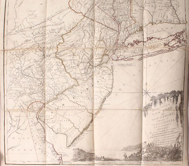
“The Provinces of New York, and New Jersey; with Part of Pensilvania, and the Province of Quebec...”
Map Maker:
Thomas Jefferys
This is Thomas Jefferys' two-sheet map based on th... (full text available to subscribers)
| Item Detail |
| |
| |
MapMaker: |
Thomas Jefferys
|
|
| |
| |
Subject: |
Colonial Northeastern United States & Quebec |
|
| |
Period/Size: |
1776 / 53.3" x 21.5" (135.4 x 54.7 cm)
|
|
| |
Color: |
Colored
|
|
| |
Condition: |
(B+) Original outline color on a sheet that has been dissected and backed with linen. There are several small worm tracks in the lower portion of the image - most notably just south of Philadelphia and in a blank area above the title cartouche. There is (condition help) |
|
| |
Source: |
|
|
| |
References: |
Goss #69; McCorkle #768.3; Sellers & Van Ee, #1045; Stevens & Tree (MCC-39) #44e. |
|
| |
|
|
| Sales Information |
| |
| |
Price: |
|
|
| |
| |
Offered by: |
Old World Auctions |
|
| |
Catalog: |
Auction No. 174 - Antique Maps, Charts, Atlases & Globes (9472) |
|
| |
Lot/Item #: |
116 |
|
| |
| |
Date: |
09/2019
|
|
| |
| |
|
Antique Maps - Valuation and Pricing, Descriptions, Resources |
|
Home |
Information |
Search |
Register |
Contact Us |
Site Map
Americana Exchange, Inc. © 1999 - 2024 Americana Exchange, Inc.. All rights reserved.
OldMaps.com, the OldMaps.com logo and
AMPR are service marks or registered service marks of Americana Exchange, Inc..
|