Title:
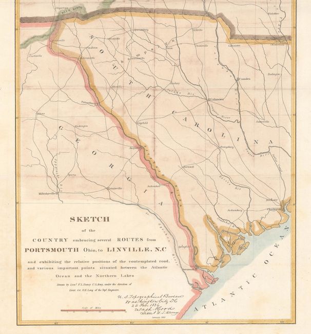
“Sketch of the Country Embracing Several Routes from Portsmouth Ohio, to Linville, N.C and Exhibiting the Relative Positions of the Contemplated Road...”
Map Maker:
U.S. Corps of Engineers
This map details the country between Lake Erie sou... (full text available to subscribers)
| Item Detail |
| |
| |
MapMaker: |
U.S. Corps of Engineers
|
|
| |
| |
Subject: |
Central & Southeast United States |
|
| |
Period/Size: |
1836 / 40.9" x 12.1" (103.9 x 30.8 cm)
|
|
| |
Color: |
Colored
|
|
| |
Condition: |
(B+) Issued folding with light scattered foxing and an edge tear confined to the bottom blank margin that has been closed on verso with archival tape. (condition help) |
|
| |
Source: |
HR Doc. 169, 24th Congress, 1st Session |
|
| |
References: |
|
|
| |
|
|
| Sales Information |
| |
| |
Price: |
|
|
| |
| |
Offered by: |
Old World Auctions |
|
| |
Catalog: |
Auction No. 174 - Antique Maps, Charts, Atlases & Globes (9472) |
|
| |
Lot/Item #: |
171 |
|
| |
| |
Date: |
09/2019
|
|
| |
| |
|
Antique Maps - Valuation and Pricing, Descriptions, Resources |
|
Home |
Information |
Search |
Register |
Contact Us |
Site Map
Americana Exchange, Inc. © 1999 - 2024 Americana Exchange, Inc.. All rights reserved.
OldMaps.com, the OldMaps.com logo and
AMPR are service marks or registered service marks of Americana Exchange, Inc..
|