Rister or Sign In to see pricing information


Title:

Iudaeae seu Terrae Israelis Tabula Geographica; in qua Locorum in Veteri et Novo Testamento Celebratissimorum Situs Accurate Descripti...

Map Maker:

Jan Jansson

Iudaeae seu Terrae Israelis Tabula Geographica; in qua Locorum in Veteri et Novo Testamento Celebratissimorum Situs Accurate Descripti...

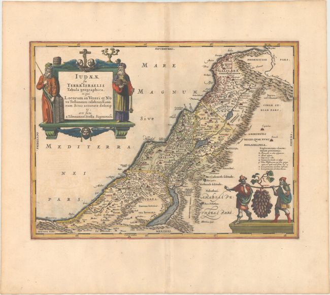
Taken from the map drawn by Tilleman Stella for Or... (full text available to subscribers)
Item Detail
 
  MapMaker:  

Jan Jansson


  Subject:  Holy Land  
  Period/Size:  1684 / 13.9" x 18.9"  (35.3 x 48.0 cm)  
  Color:  Colored  
  Condition:  (B+) A dark impression on a wide-margined sheet with light offsetting and toning along the centerfold. (condition help)  
  Source:   
  References:  Laor #373; Van der Krogt (Vol. I) #8155:1.  
 
 
Sales Information
 
  Price: 

Please register your email to view records, or sign in with email address to see records


  Offered by:  Old World Auctions  
  Catalog:  Auction No. 174 - Antique Maps, Charts, Atlases & Globes (9472)  
  Lot/Item #:  660  
 
  Date:  09/2019  


Antique Maps - Valuation and Pricing, Descriptions, Resources


Home | Information | Search | Register | Contact Us | Site Map

Americana Exchange, Inc. © 1999 - 2024 Americana Exchange, Inc.. All rights reserved. OldMaps.com, the OldMaps.com logo and
AMPR are service marks or registered service marks of Americana Exchange, Inc..