Title:
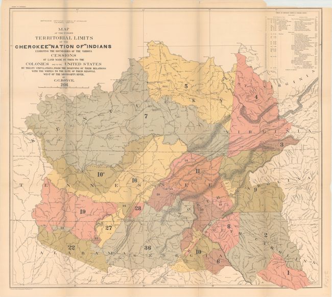
“Map of the Former Territorial Limits of the Cherokee "Nation of" Indians Exhibiting the Boundaries of the Various Cessions of Land...”
Map Maker:
Charles C. Royce
The title continues, "...Made by Them to the Colon... (full text available to subscribers)
| Item Detail |
| |
| |
MapMaker: |
Charles C. Royce
|
|
| |
| |
Subject: |
Southern United States |
|
| |
Period/Size: |
1884 / 28.5" x 31.4" (72.4 x 79.8 cm)
|
|
| |
Color: |
Colored
|
|
| |
Condition: |
(B+) Issued folding on heavy paper with pleasant minor toning and some fold separations. Fold intersections are reinforced with archival tape. There is a chip in the top right blank margin. (condition help) |
|
| |
Source: |
|
|
| |
References: |
|
|
| |
|
|
| Sales Information |
| |
| |
Price: |
|
|
| |
| |
Offered by: |
Old World Auctions |
|
| |
Catalog: |
Auction No. 174 - Antique Maps, Charts, Atlases & Globes (9472) |
|
| |
Lot/Item #: |
166 |
|
| |
| |
Date: |
09/2019
|
|
| |
| |
|
Antique Maps - Valuation and Pricing, Descriptions, Resources |
|
Home |
Information |
Search |
Register |
Contact Us |
Site Map
Americana Exchange, Inc. © 1999 - 2024 Americana Exchange, Inc.. All rights reserved.
OldMaps.com, the OldMaps.com logo and
AMPR are service marks or registered service marks of Americana Exchange, Inc..
|