Title:
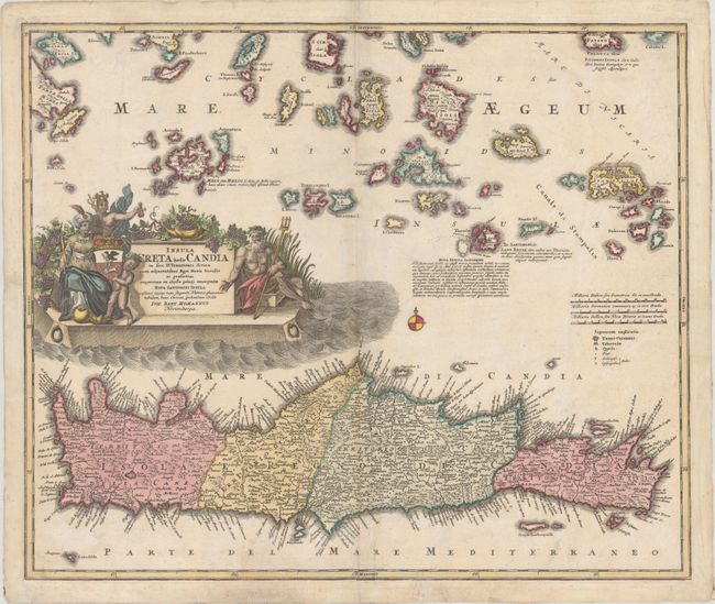
“Insula Creta Hodie Candia in sua IV. Territoria Divisa cum Adjacentibus Aegei Maris Insulis...”
Map Maker:
Johann Baptist Homann
This is a handsome, decorative map of Crete and th... (full text available to subscribers)
| Item Detail |
| |
| |
MapMaker: |
Johann Baptist Homann
|
|
| |
| |
Subject: |
Crete |
|
| |
Period/Size: |
1730 / 19.0" x 22.6" (48.3 x 57.4 cm)
|
|
| |
Color: |
Colored
|
|
| |
Condition: |
(B+) A nice impression on watermarked paper with light soiling and several edge tears that enter the border and have been archivally repaired on verso. (condition help) |
|
| |
Source: |
Neuer Atlas Bestehend... |
|
| |
References: |
|
|
| |
|
|
| Sales Information |
| |
| |
Price: |
|
|
| |
| |
Offered by: |
Old World Auctions |
|
| |
Catalog: |
Auction No. 174 - Antique Maps, Charts, Atlases & Globes (9472) |
|
| |
Lot/Item #: |
630 |
|
| |
| |
Date: |
09/2019
|
|
| |
| |
|
Antique Maps - Valuation and Pricing, Descriptions, Resources |
|
Home |
Information |
Search |
Register |
Contact Us |
Site Map
Americana Exchange, Inc. © 1999 - 2024 Americana Exchange, Inc.. All rights reserved.
OldMaps.com, the OldMaps.com logo and
AMPR are service marks or registered service marks of Americana Exchange, Inc..
|