Title:
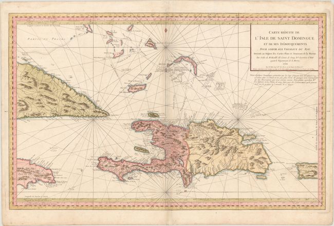
“Carte Reduite de l'Isle de Saint Domingue et de ses Debouquements pour Servir aux Vaisseaux du Roy...”
Map Maker:
Jacques Nicolas Bellin
This gorgeous, large-scale chart covers Hispaniola... (full text available to subscribers)
| Item Detail |
| |
| |
MapMaker: |
Jacques Nicolas Bellin
|
|
| |
| |
Subject: |
Hispaniola |
|
| |
Period/Size: |
1754 / 21.8" x 34.9" (55.4 x 88.7 cm)
|
|
| |
Color: |
Colored
|
|
| |
Condition: |
(B+) A nice example on a sturdy sheet with the watermark of a double-headed eagle with a heart. There is minor soiling and archival repairs to some separations along the centerfold. (condition help) |
|
| |
Source: |
L'Hydrographie Francoise |
|
| |
References: |
|
|
| |
|
|
| Sales Information |
| |
| |
Price: |
|
|
| |
| |
Offered by: |
Old World Auctions |
|
| |
Catalog: |
Auction No. 174 - Antique Maps, Charts, Atlases & Globes (9472) |
|
| |
Lot/Item #: |
310 |
|
| |
| |
Date: |
09/2019
|
|
| |
| |
|
Antique Maps - Valuation and Pricing, Descriptions, Resources |
|
Home |
Information |
Search |
Register |
Contact Us |
Site Map
Americana Exchange, Inc. © 1999 - 2024 Americana Exchange, Inc.. All rights reserved.
OldMaps.com, the OldMaps.com logo and
AMPR are service marks or registered service marks of Americana Exchange, Inc..
|