Title:
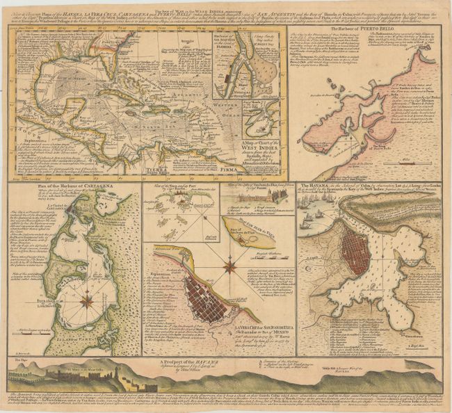
“The Seat of War in the West Indies, Containing New & Accurate Plans of the Havana, la Vera Cruz, Cartagena and Puerto Bello...”
Map Maker:
George Foster
This is a separately-issued sheet containing a com... (full text available to subscribers)
| Item Detail |
| |
| |
MapMaker: |
George Foster
|
|
| |
| |
Subject: |
Gulf of Mexico & Caribbean |
|
| |
Period/Size: |
1740 / 15.4" x 18.2" (39.2 x 46.3 cm)
|
|
| |
Color: |
Colored
|
|
| |
Condition: |
(B+) A crisp impression with minor toning and soiling, a small hole in Louisiana, and a couple of short edge tears at bottom that have been closed on verso. (condition help) |
|
| |
Source: |
|
|
| |
References: |
|
|
| |
|
|
| Sales Information |
| |
| |
Price: |
|
|
| |
| |
Offered by: |
Old World Auctions |
|
| |
Catalog: |
Auction No. 174 - Antique Maps, Charts, Atlases & Globes (9472) |
|
| |
Lot/Item #: |
296 |
|
| |
| |
Date: |
09/2019
|
|
| |
| |
|
Antique Maps - Valuation and Pricing, Descriptions, Resources |
|
Home |
Information |
Search |
Register |
Contact Us |
Site Map
Americana Exchange, Inc. © 1999 - 2024 Americana Exchange, Inc.. All rights reserved.
OldMaps.com, the OldMaps.com logo and
AMPR are service marks or registered service marks of Americana Exchange, Inc..
|