Title:
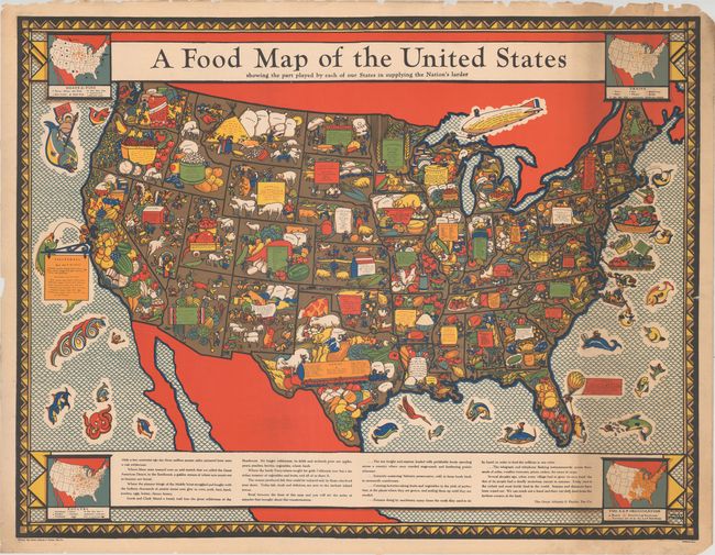
“A Food Map of the United States Showing the Part Played by Each of Our States in Supplying the Nation's Larder”
Map Maker:
Infrequent Publ. - Advertising
This remarkable large map was drawn by Louis Fanch... (full text available to subscribers)
| Item Detail |
| |
| |
MapMaker: |
Infrequent Publ. - Advertising
|
|
| |
| |
Subject: |
United States |
|
| |
Period/Size: |
1932 / 33.0" x 43.1" (83.9 x 109.5 cm)
|
|
| |
Color: |
Colored
|
|
| |
Condition: |
(B+) A colorful example with a number of small edge tears and edge chips mostly in the margins. Longer tears that enter 6" into the image at right and 14" into the image at left have been closed on verso with archival tape. (condition help) |
|
| |
Source: |
|
|
| |
References: |
Rumsey #9754. |
|
| |
|
|
| Sales Information |
| |
| |
Price: |
|
|
| |
| |
Offered by: |
Old World Auctions |
|
| |
Catalog: |
Auction No. 174 - Antique Maps, Charts, Atlases & Globes (9472) |
|
| |
Lot/Item #: |
126 |
|
| |
| |
Date: |
09/2019
|
|
| |
| |
|
Antique Maps - Valuation and Pricing, Descriptions, Resources |
|
Home |
Information |
Search |
Register |
Contact Us |
Site Map
Americana Exchange, Inc. © 1999 - 2024 Americana Exchange, Inc.. All rights reserved.
OldMaps.com, the OldMaps.com logo and
AMPR are service marks or registered service marks of Americana Exchange, Inc..
|