Title:
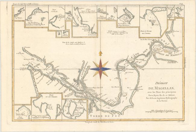
“Detroit de Magellan, avec les Plans des Principaux Ports, Bayes &c. de ce Detroit”
Map Maker:
Rigobert Bonne
This is a very detailed chart of the Straits of Ma... (full text available to subscribers)
| Item Detail |
| |
| |
MapMaker: |
Rigobert Bonne
|
|
| |
| |
Subject: |
Strait of Magellan |
|
| |
Period/Size: |
1787 / 9.2" x 13.5" (23.4 x 34.3 cm)
|
|
| |
Color: |
Colored
|
|
| |
Condition: |
(B+) Watermarked paper with a couple extraneous folds, minor offsetting, and a few small spots. (condition help) |
|
| |
Source: |
Atlas Encyclopedique |
|
| |
References: |
|
|
| |
|
|
| Sales Information |
| |
| |
Price: |
|
|
| |
| |
Offered by: |
Old World Auctions |
|
| |
Catalog: |
Auction No. 174 - Antique Maps, Charts, Atlases & Globes (9472) |
|
| |
Lot/Item #: |
372 |
|
| |
| |
Date: |
09/2019
|
|
| |
| |
|
Antique Maps - Valuation and Pricing, Descriptions, Resources |
|
Home |
Information |
Search |
Register |
Contact Us |
Site Map
Americana Exchange, Inc. © 1999 - 2024 Americana Exchange, Inc.. All rights reserved.
OldMaps.com, the OldMaps.com logo and
AMPR are service marks or registered service marks of Americana Exchange, Inc..
|