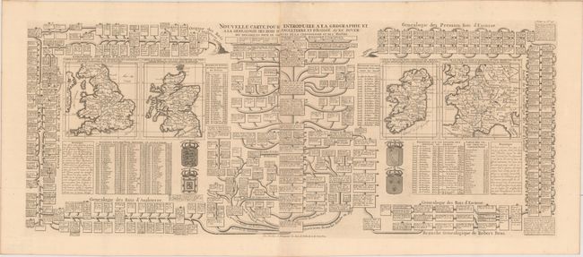
Title:
“Nouvelle Carte pour Introduire a la Geographie et a la Genealogie des Rois d'Angleterre et d'Ecosse...”
Map Maker:
Henry Abraham Chatelain
This fascinating chart extends across two joined s... (full text available to subscribers)
| Item Detail |
| |
| |
MapMaker: |
Henry Abraham Chatelain
|
|
| |
| |
Subject: |
Britain, France |
|
| |
Period/Size: |
1720 / 14.5" x 36.3" (36.9 x 92.2 cm)
|
|
| |
Color: |
Black & White
|
|
| |
Condition: |
(B+) A nice impression on a sheet with a Strasbourg bend and lily watermark. There is light toning mostly along the joint and some faint offsetting. (condition help) |
|
| |
Source: |
Atlas Historique |
|
| |
References: |
|
|
| |
|
|
| Sales Information |
| |
| |
Price: |
|
|
| |
| |
Offered by: |
Old World Auctions |
|
| |
Catalog: |
Auction No. 174 - Antique Maps, Charts, Atlases & Globes (9472) |
|
| |
Lot/Item #: |
400 |
|
| |
| |
Date: |
09/2019
|
|
| |
| |
|
Antique Maps - Valuation and Pricing, Descriptions, Resources |
|
Home |
Information |
Search |
Register |
Contact Us |
Site Map
Americana Exchange, Inc. © 1999 - 2024 Americana Exchange, Inc.. All rights reserved.
OldMaps.com, the OldMaps.com logo and
AMPR are service marks or registered service marks of Americana Exchange, Inc..
|