Title:
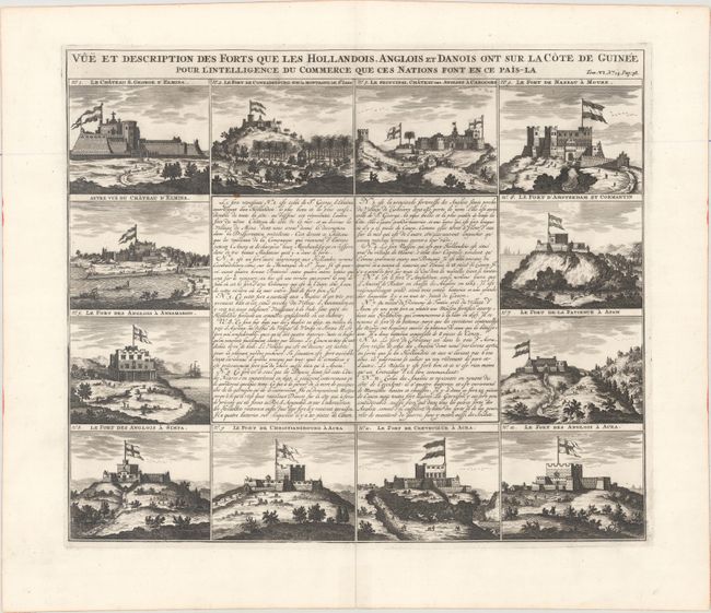
“Vue et Description des Forts que les Hollandois, Anglois et Danois ont sur la Cote de Guinee pour l'Intelligence du Commerce que ces Nations font en ce Pais-la”
Map Maker:
Henry Abraham Chatelain
This is a unique sheet with twelve views of forts ... (full text available to subscribers)
| Item Detail |
| |
| |
MapMaker: |
Henry Abraham Chatelain
|
|
| |
| |
Subject: |
Western Africa, Forts |
|
| |
Period/Size: |
1720 / 14.5" x 17.0" (36.9 x 43.2 cm)
|
|
| |
Color: |
Black & White
|
|
| |
Condition: |
(A) A fine dark impression on a sheet with a Strasbourg bend and lily watermark. There is a centerfold separation that just enters the neatline at bottom that has been closed on verso with archival tape. (condition help) |
|
| |
Source: |
Atlas Historique |
|
| |
References: |
|
|
| |
|
|
| Sales Information |
| |
| |
Price: |
|
|
| |
| |
Offered by: |
Old World Auctions |
|
| |
Catalog: |
Auction No. 174 - Antique Maps, Charts, Atlases & Globes (9472) |
|
| |
Lot/Item #: |
761 |
|
| |
| |
Date: |
09/2019
|
|
| |
| |
|
Antique Maps - Valuation and Pricing, Descriptions, Resources |
|
Home |
Information |
Search |
Register |
Contact Us |
Site Map
Americana Exchange, Inc. © 1999 - 2024 Americana Exchange, Inc.. All rights reserved.
OldMaps.com, the OldMaps.com logo and
AMPR are service marks or registered service marks of Americana Exchange, Inc..
|