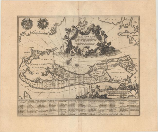
Title:
“Mappa Aestivarum Insularum, Alias Barmudas Dictarum, ad Ostia Mexicani Aestuary...”
Map Maker:
Montanus/Ogilby
This attractive map is based on Blaeu's chart of t... (full text available to subscribers)
| Item Detail |
| |
| |
MapMaker: |
Montanus/Ogilby
|
|
| |
| |
Subject: |
Bermuda |
|
| |
Period/Size: |
1671 / 11.4" x 14.0" (29.0 x 35.6 cm)
|
|
| |
Color: |
Black & White
|
|
| |
Condition: |
(A) A sharp impression with faint toning and some light rippling around the centerfold. (condition help) |
|
| |
Source: |
America |
|
| |
References: |
Palmer (MCC-19) #12; Shirley (BL Atlases) T.OGIL-2a #19. |
|
| |
|
|
| Sales Information |
| |
| |
Price: |
|
|
| |
| |
Offered by: |
Old World Auctions |
|
| |
Catalog: |
Auction No. 177 - Antique Maps, Charts, Atlases & Globes (9498) |
|
| |
Lot/Item #: |
350 |
|
| |
| |
Date: |
04/2020
|
|
| |
| |
|
Antique Maps - Valuation and Pricing, Descriptions, Resources |
|
Home |
Information |
Search |
Register |
Contact Us |
Site Map
Americana Exchange, Inc. © 1999 - 2024 Americana Exchange, Inc.. All rights reserved.
OldMaps.com, the OldMaps.com logo and
AMPR are service marks or registered service marks of Americana Exchange, Inc..
|