Title:
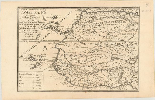
“Partie Occidentale d'Afrique ou se Trouve les Isles Canaries, et du Cap Verd dans la Mer Atlantique les Etats du Roy de Maroc, les Royaumes d'Alger et de Tunis...”
Map Maker:
Nicolas de Fer
This sharply engraved map of western Africa provid... (full text available to subscribers)
| Item Detail |
| |
| |
MapMaker: |
Nicolas de Fer
|
|
| |
| |
Subject: |
Northwestern Africa |
|
| |
Period/Size: |
1717 / 8.9" x 12.8" (22.6 x 32.6 cm)
|
|
| |
Color: |
Black & White
|
|
| |
Condition: |
(A) On watermarked paper with a few spots of printer's ink in the title cartouche. (condition help) |
|
| |
Source: |
Atlas Curieux |
|
| |
References: |
Pastoureau, FER ID #118. |
|
| |
|
|
| Sales Information |
| |
| |
Price: |
|
|
| |
| |
Offered by: |
Old World Auctions |
|
| |
Catalog: |
Auction No. 177 - Antique Maps, Charts, Atlases & Globes (9498) |
|
| |
Lot/Item #: |
692 |
|
| |
| |
Date: |
04/2020
|
|
| |
| |
|
Antique Maps - Valuation and Pricing, Descriptions, Resources |
|
Home |
Information |
Search |
Register |
Contact Us |
Site Map
Americana Exchange, Inc. © 1999 - 2024 Americana Exchange, Inc.. All rights reserved.
OldMaps.com, the OldMaps.com logo and
AMPR are service marks or registered service marks of Americana Exchange, Inc..
|