Title:
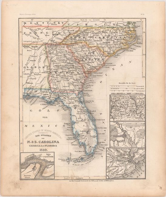
“(United States of North America) Die Staaten von N. & S. Carolina Georgia & Florida”
Map Maker:
Bibliographisches Institut
This very detailed German map of the southeastern ... (full text available to subscribers)
| Item Detail |
| |
| |
MapMaker: |
Bibliographisches Institut
|
|
| |
| |
Subject: |
Southeast United States |
|
| |
Period/Size: |
1850 / 9.9" x 7.8" (25.2 x 19.9 cm)
|
|
| |
Color: |
Colored
|
|
| |
Condition: |
(B+) Contemporary outline color with light soiling primarily in the blank margins. (condition help) |
|
| |
Source: |
Meyer's Zeitungs-Atlas |
|
| |
References: |
|
|
| |
|
|
| Sales Information |
| |
| |
Price: |
|
|
| |
| |
Offered by: |
Old World Auctions |
|
| |
Catalog: |
Auction No. 177 - Antique Maps, Charts, Atlases & Globes (9498) |
|
| |
Lot/Item #: |
139 |
|
| |
| |
Date: |
04/2020
|
|
| |
| |
|
Antique Maps - Valuation and Pricing, Descriptions, Resources |
|
Home |
Information |
Search |
Register |
Contact Us |
Site Map
Americana Exchange, Inc. © 1999 - 2024 Americana Exchange, Inc.. All rights reserved.
OldMaps.com, the OldMaps.com logo and
AMPR are service marks or registered service marks of Americana Exchange, Inc..
|