Title:
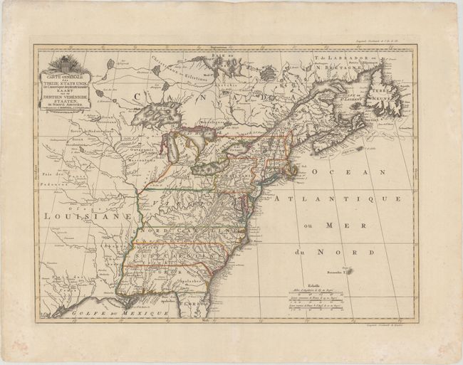
“Carte Generale des Treize Etats Unis, de l'Amerique Septentrionale / Kaart van de Dertien Verenigde Staaten, in Noord Amerika”
Map Maker:
Covens & Mortier
This very uncommon map depicts the recently formed... (full text available to subscribers)
| Item Detail |
| |
| |
MapMaker: |
Covens & Mortier
|
|
| |
| |
Subject: |
Eastern United States |
|
| |
Period/Size: |
1783 / 16.1" x 22.2" (40.9 x 56.4 cm)
|
|
| |
Color: |
Colored
|
|
| |
Condition: |
(A) A crisp impression on a sheet with a "C. & I. Honig" watermark. There are a few minor spots and a tiny abrasion in Canada near the centerfold. (condition help) |
|
| |
Source: |
|
|
| |
References: |
McCorkle #785.3; Sellers & Van Ee #760. |
|
| |
|
|
| Sales Information |
| |
| |
Price: |
|
|
| |
| |
Offered by: |
Old World Auctions |
|
| |
Catalog: |
Auction No. 177 - Antique Maps, Charts, Atlases & Globes (9498) |
|
| |
Lot/Item #: |
113 |
|
| |
| |
Date: |
04/2020
|
|
| |
| |
|
Antique Maps - Valuation and Pricing, Descriptions, Resources |
|
Home |
Information |
Search |
Register |
Contact Us |
Site Map
Americana Exchange, Inc. © 1999 - 2024 Americana Exchange, Inc.. All rights reserved.
OldMaps.com, the OldMaps.com logo and
AMPR are service marks or registered service marks of Americana Exchange, Inc..
|