Title:
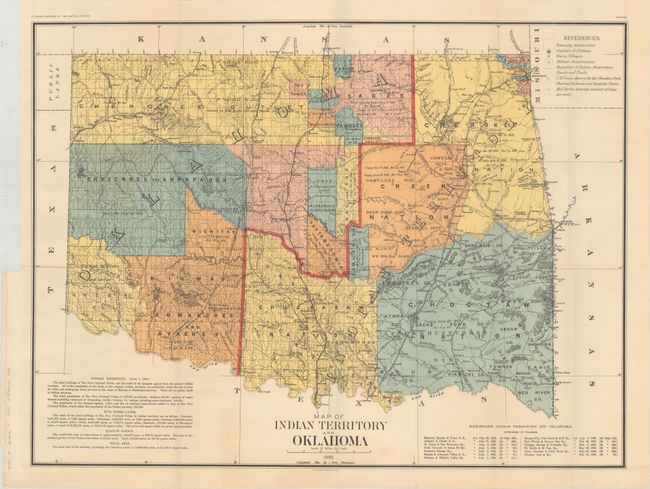
“Map of Indian Territory and Oklahoma”
Map Maker:
U.S. Government
Large, colorful, and historically significant map ... (full text available to subscribers)
| Item Detail |
| |
| |
MapMaker: |
U.S. Government
|
|
| |
| |
Subject: |
Oklahoma |
|
| |
Period/Size: |
1890 / 22.1" x 29.4" (56.2 x 74.7 cm)
|
|
| |
Color: |
Colored
|
|
| |
Condition: |
(A) A clean and colorful example with some minor rippling of the paper adjacent to the vertical folds.
Issued folding. (condition help) |
|
| |
Source: |
Eleventh Census of the United States |
|
| |
References: |
|
|
| |
|
|
| Sales Information |
| |
| |
Price: |
|
|
| |
| |
Offered by: |
Old World Auctions |
|
| |
Catalog: |
Auction No. 177 - Antique Maps, Charts, Atlases & Globes (9498) |
|
| |
Lot/Item #: |
233 |
|
| |
| |
Date: |
04/2020
|
|
| |
| |
|
Antique Maps - Valuation and Pricing, Descriptions, Resources |
|
Home |
Information |
Search |
Register |
Contact Us |
Site Map
Americana Exchange, Inc. © 1999 - 2024 Americana Exchange, Inc.. All rights reserved.
OldMaps.com, the OldMaps.com logo and
AMPR are service marks or registered service marks of Americana Exchange, Inc..
|