Title:
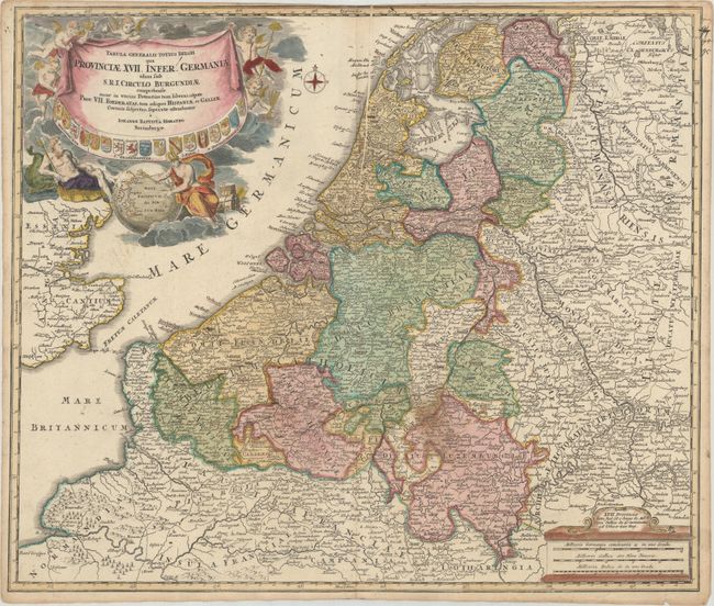
“Tabula Generalis Totius Belgii qua Provinciae XVII. Infer. Germaniae olim sub S.R.I. Circulo Burgundiae...”
Map Maker:
Johann Baptist Homann
A detailed and decorative map of the Netherlands, ... (full text available to subscribers)
| Item Detail |
| |
| |
MapMaker: |
Johann Baptist Homann
|
|
| |
| |
Subject: |
Low Countries |
|
| |
Period/Size: |
1716 / 19.1" x 22.6" (48.6 x 57.4 cm)
|
|
| |
Color: |
Colored
|
|
| |
Condition: |
(B+) A nice impression on paper with an "SS" watermark, contemporary color in the map and later color in the cartouche. There is a stain east of Namur, a printer's crease adjacent to the centerfold at top and light toning along the edges of the sheet. T (condition help) |
|
| |
Source: |
|
|
| |
References: |
|
|
| |
|
|
| Sales Information |
| |
| |
Price: |
|
|
| |
| |
Offered by: |
Old World Auctions |
|
| |
Catalog: |
Auction No. 177 - Antique Maps, Charts, Atlases & Globes (9498) |
|
| |
Lot/Item #: |
418 |
|
| |
| |
Date: |
04/2020
|
|
| |
| |
|
Antique Maps - Valuation and Pricing, Descriptions, Resources |
|
Home |
Information |
Search |
Register |
Contact Us |
Site Map
Americana Exchange, Inc. © 1999 - 2024 Americana Exchange, Inc.. All rights reserved.
OldMaps.com, the OldMaps.com logo and
AMPR are service marks or registered service marks of Americana Exchange, Inc..
|