Title:
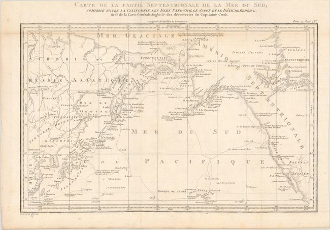
“Carte de la Partie Septentrionale de la Mer du Sud, Comprise Entre la Californie, les Isles Sandwich, le Japon et le Detrt. de Behring...”
Map Maker:
James Cook
This fine map is based on the Henry Roberts/Cook c... (full text available to subscribers)
| Item Detail |
| |
| |
MapMaker: |
James Cook
|
|
| |
| |
Subject: |
North Pacific Ocean |
|
| |
Period/Size: |
1785 / 9.3" x 14.6" (23.7 x 37.1 cm)
|
|
| |
Color: |
Black & White
|
|
| |
Condition: |
(B+) Issued folding with light toning along the horizontal fold at top and some minor scattered foxing. (condition help) |
|
| |
Source: |
Prevost's Histoire Generale des Voyages |
|
| |
References: |
|
|
| |
|
|
| Sales Information |
| |
| |
Price: |
|
|
| |
| |
Offered by: |
Old World Auctions |
|
| |
Catalog: |
Auction No. 178 - Antique Maps, Charts, Atlases & Globes (9499) |
|
| |
Lot/Item #: |
540 |
|
| |
| |
Date: |
06/2020
|
|
| |
| |
|
Antique Maps - Valuation and Pricing, Descriptions, Resources |
|
Home |
Information |
Search |
Register |
Contact Us |
Site Map
Americana Exchange, Inc. © 1999 - 2024 Americana Exchange, Inc.. All rights reserved.
OldMaps.com, the OldMaps.com logo and
AMPR are service marks or registered service marks of Americana Exchange, Inc..
|