Title:
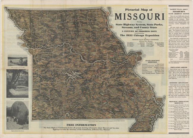
“Pictorial Map of Missouri Showing State Highway System, State Parks, Streams, and County Seats - A Century of Progress Issue Commemorating the 1933 Chicago Exposition”
Map Maker:
Infrequent Publ. - Local & State Maps
This handsome map of the Show Me State was commiss... (full text available to subscribers)
| Item Detail |
| |
| |
MapMaker: |
Infrequent Publ. - Local & State Maps
|
|
| |
| |
Subject: |
Missouri |
|
| |
Period/Size: |
1933 / 18.7" x 23.9" (47.5 x 60.7 cm)
|
|
| |
Color: |
Colored
|
|
| |
Condition: |
(B+) Issued folding, now flat, with minor toning along several of the folds and some separations along the folds that have been repaired on verso with archival materials, with small losses at fold intersections. (condition help) |
|
| |
Source: |
|
|
| |
References: |
|
|
| |
|
|
| Sales Information |
| |
| |
Price: |
|
|
| |
| |
Offered by: |
Old World Auctions |
|
| |
Catalog: |
Auction No. 178 - Antique Maps, Charts, Atlases & Globes (9499) |
|
| |
Lot/Item #: |
180 |
|
| |
| |
Date: |
06/2020
|
|
| |
| |
|
Antique Maps - Valuation and Pricing, Descriptions, Resources |
|
Home |
Information |
Search |
Register |
Contact Us |
Site Map
Americana Exchange, Inc. © 1999 - 2024 Americana Exchange, Inc.. All rights reserved.
OldMaps.com, the OldMaps.com logo and
AMPR are service marks or registered service marks of Americana Exchange, Inc..
|