Title:
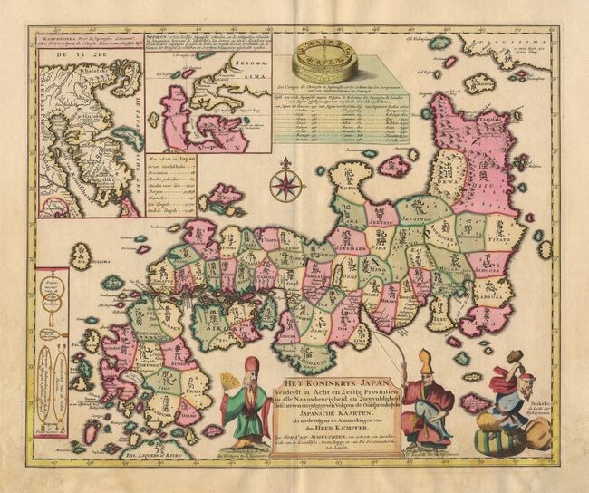
“Het Koninkryk Japan verdeelt in Acht en Zestig Provintien in alle Naauwkeurigheid en Zorgvuldigheid Beschreven en uytgegeven volgens de Oorspronkelyke Japansche Kaarten, als mede volgens den Aanmerkingen van den Heer Kaemfer”
Map Maker:
Kaempfer/Scheuchzer
This superb map was prepared by Johann Caspar Sche... (full text available to subscribers)
| Item Detail |
| |
| |
MapMaker: |
Kaempfer/Scheuchzer
|
|
| |
| |
Subject: |
Japan |
|
| |
Period/Size: |
1728 / 16.8" x 20.5" (42.7 x 52.1 cm)
|
|
| |
Color: |
Colored
|
|
| |
Condition: |
(A) Minor damp stain in margins, just touching bottom border with expert paper restoration of corner. (condition help) |
|
| |
Source: |
|
|
| |
References: |
Walter #76-77. |
|
| |
|
|
| Sales Information |
| |
| |
Price: |
|
|
| |
| |
Offered by: |
Old World Auctions |
|
| |
Catalog: |
Auction No. 97 - Antique Maps, Charts, Atlases & Globes (169) |
|
| |
Lot/Item #: |
429 |
|
| |
| |
Date: |
12/2001
|
|
| |
| |
|
Antique Maps - Valuation and Pricing, Descriptions, Resources |
|
Home |
Information |
Search |
Register |
Contact Us |
Site Map
Americana Exchange, Inc. © 1999 - 2024 Americana Exchange, Inc.. All rights reserved.
OldMaps.com, the OldMaps.com logo and
AMPR are service marks or registered service marks of Americana Exchange, Inc..
|